|
|

|

|

|
WATER & DROUGHT
“As you get more global warming, you should see an increase in the extremes of the hydrological cycle – droughts and floods and heavy precipitation.” — James Hansen

Lest We Forget: Precious Water is Vital!

by Frank Dietz, for the H-Z February 3, 2024
How wondrous has been our recent drought-denting rainfall! With more winter in front of us, “it’s fresh
like Spring.” The pastures and our yard where we live are finally green. May 2024 be notably wet.
My first Texas employment was in “Aggieland” located in Brazos County. Among many interesting folk
was a young faculty person at Texas A&M who also served as a specialist with the Extension Service
(now AgriLife). In a presentation to rural and small-town pastors the specialist spoke to us about “Aqua
Amnesia.” As a native of New Orleans and years growing up on the Gulf Coast, I found it curious to hear
about how frustratingly dry things can be in Texas. The presenter convincingly described the 1950’s of
his adolescence when the A&M campus and much of Texas were scorched to a crisp with little
vegetation surviving. He got a laughing response when he said, “our sacred Kyle Field where football
rules was a standout exhibit of green amidst all the brown surroundings.” He pointed out that in the
late 1960’s a vast hurricane had “greened up” just about everything. The concern he expressed was that
measures that were undertaken during drought times and even legislation to address water deficits
“evaporated” rapidly in a state of “aqua amnesia.” Many rushed back to old consumption practices for
irrigation, drilling, industrial, and household uses as if it was a time for “no worry” going forward.
We can hope that the recently dry riverbeds of our Texas Hill Country and dropping water tables will not
be ignored going forward. I raise this, in part, in response to a number of our own Comal County
readers and neighbors asking me if I’d say something about the wells going dry, the periodic interruption
of well flows, dry or trickling in our assumed wonderfully vigorous springs and more. There commenced
discussions about coaxing folks to utilize landscaping practices and household water consumption with
greater measures of stewarding our water supplies. More general questions were initiated about how
to use more prudent practices in the rapid development of Comal County and the neighboring Hill
Country region. When a group of folks with well worries spoke of how long they would wait before a
drilling service could extend the depth of their wells or drill a new well, discussions deepened. Might
the licensing process be examined for greater cautionary measures? Would the drillers be willing to tell
us anecdotally if not scientifically what they are seeing and encountering when they tell customers
about their waiting lists? What discussions might be underway with policy making elected and staff
officials that address our water precariousness? Might we begin acknowledging “right to capture”
principles require some reiteration in light of the population swell and so many more “taking” from our
finite water sources?
Let’s begin with planting/sowing less thirsty choices. Let’s look to newer measures for recycling much
used water. Let’s explore what some innovators describe and demonstrate as ONE WATER buildings.
Consider pervious rather than impervious cover whenever possible in your own space as well as in our
public and commercial spaces. The lists go on!
How my life circumstances have taken me on a water journey! As a youngster, I watched adults pound
pipes into sandy soil to “find water.” Now I wonder how deep some with mighty drills must reach. Let’s
talk together rather than allow our Springs and much more to go dry.

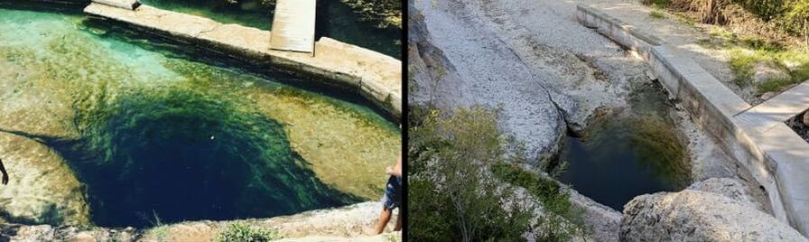
Before and after photos show dire conditions at popular swimming hole Jacob’s Well
By Mary Claire Patton
Published August 2, 2023 (Source)
Swimming hasn’t been allowed at Jacob’s Well for the past two summers and newly posted photos of the spring-fed swimming hole make it clear why the Hill Country hot spot has been closed.
Hays County officials, who shared photos of a dried-up creek bed with KSAT on Tuesday, announced last summer that Jacob’s Well would be closed for swimming for the “foreseeable future.” In April, they said swimming will remain a no-go due to water levels and spring flow.
Under normal conditions, Jacob’s Well releases thousands of gallons of water every day from the Trinity Aquifer, which comes from an extensive underground cave system, according to Hays County Parks officials.
However, the lack of rainfall coupled with some of the hottest summer months on record have all but dried up the famous swimming hole.
The Watershed Association, a local nonprofit organization that keeps Jacob’s Well and the headwaters of Cypress Creek, clean, clear and flowing, posted an update on social media over the weekend stating that the spring is measuring at zero flow for the sixth time since 2000.
“There are multiple factors contributing to Jacob’s Well’s near-dry condition, and it’s crucial to recognize that it’s not just one issue at play,” Watershed officials said.
They also mentioned the extreme and exceptional drought conditions Central Texas has been experiencing the past few years and added that “increased groundwater demand to accommodate rapid population growth is resulting in more and more water being withdrawn in Woodcreek North, across the region.”
Anthony Shepherd of the Hays County Parks Department told KSAT on Tuesday that Jacob’s Well will remain closed for swimming for the foreseeable future.
“We are still open for visitors to come view the well and hike our trails, but no water access will be permitted,” Shepherd said.
KSAT has reached out the Hays County officials regarding the over-pumping of groundwater in the area.


'It's heartbreaking': Jacob's Well stops flowing for sixth time in recorded history
By Maya Fawaz (Photo by Michael Minasi)
Published August 2, 2023 (Source)
Jacob's Well, the popular spring-fed swimming hole in Wimberley, has reached zero flow for the sixth time in its recorded history. All six of those times have occurred in the last 23 years — and it's become more frequent.
Earlier this summer, the Hays County park announced Jacob's Well had low flow and would likely not open for swimming. Now, its flow has stopped entirely.
David Baker, executive director of the nonprofit The Watershed Association, has worked to protect the well and the surrounding natural environment for almost 30 years. He said this is the worst he’s ever seen it.
“It's heartbreaking,” he said. “We've worked so hard. The community has invested lots of money in buying up land to protect it.”
Low water levels at Jacob’s Well have been a recurring issue, and experts say the well’s health is an indicator of the region’s water supply. Baker says more water is taken out of the aquifers each year and not enough is going back in to recharge them.
“There’s no water flowing out of the creek at all,” Baker said. “We're still in a very severe extreme drought here in Central Texas. You look at the drought monitor and you'll see that big, dark brown circle there in the middle of Texas.”
The City of Wimberley entered Stage 4 drought conditions on Tuesday. The Hays Trinity Groundwater Conservation District will need to decrease its water use district-wide by 40% — and by 30% within the Jacob’s Well Groundwater Management Zone. The district says both the Pedernales and Blanco rivers are experiencing record-low flows.
“It's really an ecological disaster, it's an economic disaster,” Baker said. “The county has lost hundreds of thousands of dollars in revenue from not being able to allow swimmers there for the past two summers.”
Blue Hole Regional Park, another nearby swimming hole in the Hill Country, has remained open. Baker says smaller springs have helped keep Cypress Creek flowing, but the creek is being tested weekly to ensure bacteria levels don’t get too high as water has been flowing slower than usual.
“As these flows diminish, it threatens aquatic life,” he said. “There are huge sections of the creek that are completely bone dry. No water at all.”
The Wimberley Water Supply Corporation says water levels within the Middle Trinity Aquifer — which supplies Jacob's Well — are dropping at an alarming rate due to high temperatures, population increase, lack of rainfall, tourism and development.
The City of Wimberley has tips to start water conservation efforts indoors, outdoors and in commercial facilities on their website.


Frank Dietz, Comal County resident,
CCCA Board Member, &
Herald Zeitung monthly columnist
WE NEED RAIN NOW!!!
August 2022
|
As our 2022 seasons transitioned from late winter to spring, our surrounding yard areas required early season attention. After these early touchups, it became evident our well-worn mower was ready for replacement. In early May we assumed periodic rains would produce the need for mowing. Some investigation indicated we might choose to move to battery powered heavy-duty equipment this time. An order was placed, replacement arrived and it still remains “ready and waiting.” Our expectations for rainfall have been left wanting, becoming desperate as the weeks come and go. It is as if from then until now a rare dark cloud passes our way overhead and finds our readiness and waiting mockingly laughable. We have even heard thunder a time or two. But, alas, it is anything but a joke! The drought deepens weekly and the stressors abound.
In this week of writing, Jacob’s well in Wimberly has gone dry for only the fourth time ever. This caps a series of reports from friends, family and correspondents about worrisome images across our Texas Hill Country. Images of riverbeds gone dry and looking more like an empty roadway bed; little pools of water with desperate fish, some the threatened Guadalupe bass; stories of stranded docks and boat launchings. Others have called attention to the frailty of wildlife and the super crowded influx of livestock going to auction. We have even had a nearby wildfire scare that left scorched acreage as a caution. My most haunting image comes from my marvelous wife of 59 years and friend for 66 describing a 1950’s trip with younger siblings on the train from the verdant green stretches of the Midwest through a long stretch of Texas where her Comal County grandparents and aunt met them at the downtown New Braunfels depot. She said the deeper they came into Texas, the drier the landscape with |
occasional frightful sightings of emaciated cattle. Peering from the train windows or landings where you could look out between coaches back then, the savaging of Texas by deep drought cried out! Today along with the images of wildfires even nearby gives one shivers.
The ominous signs of these periodic droughts, especially noting records that show the recent recordings of severe precipitation deprivation clustering in our recent decades gives one pause. I know there are those insistent that we cannot have conversation using “global warming” or “climate change” without creating division. So, let’s just allow the circumstances to shake us into some reality thinking and reflection. It would seem a “no brainer” that those among us in Comal County and neighbors of the Texas Hill Country working to protect and set aside “green” acres in conservation protection are about a good thing. As the aquifers strain to provide, such efforts above recharge areas seem urgent. Likewise, isn’t it a considerable shortsightedness to have “stages for conservation” with our water supplies as these stressful periods are notably more frequent? It is high time for policy revisions. In a state so dependent upon underground water resources, the time has come for policy that establishes scientific oversight as well. A recent revisit of my TEXAS WATER ATLAS proved instructive. An update in projections of population growth bringing water “takes” at more rapid rates is needed to note the exponential growth in our Texas Hill Country and “along the corridor.” Our withering summer sounds the alarms. Yes, friends, conserve, landscape in drought hardy ways and make provision to capture rainwaters. The time to “do water” responsibly is now! Resources are readily accessible at www.comalconservation.org and our excellent local libraries. |

William Luther/Staff
Drought drama: With Edwards Aquifer low and waterways drying up, more restrictions could be coming
By Elena Bruess
April 10, 2023
April 10, 2023
By the time the area's drought reached its third year, the creeks and rivers of South Central Texas had long dried up. For most, it happened slowly, shrinking over time until just a puddle remained. For others, it was a shock. One summer, there was water. The next, there was none. Either way, the waterways that normally flowed through the Hill Country had dried into the rock beds and the time for swimming was over.
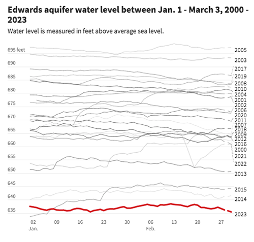
The ongoing drought's repercussions are clear in the San Antonio area. River and creek flows are at the slowest they have ever been, lakes are dried up or are drying up and, from January to March this year, the Edwards Aquifer's water levels reached their lowest levels since the record drought of the 1950s. Without normal rainfall, the agency that manages the aquifer could find itself implementing Stage 4 restrictions earlier this year than any time in its history.
The ongoing drought's repercussions are clear in the San Antonio area. River and creek flows are at the slowest they have ever been, lakes are dried up or are drying up and, from January to March this year, the Edwards Aquifer's water levels reached their lowest levels since the record drought of the 1950s. Without normal rainfall, the agency that manages the aquifer could find itself implementing Stage 4 restrictions earlier this year than any time in its history.
Over 2 million people, including thousands of farmers, depend on water from the Edwards Aquifer, a porous limestone cavern system spanning hundreds of feet underground and across 3,600 square miles. The aquifer provides the San Antonio Water System with just over 50 percent of its water supply.
The aquifer’s current water level is at 635 feet, having dropped more than 15 feet in the past year and about 2 feet in the past 10 days. When the rolling average drops below 630 feet, it will trigger the Edwards Aquifer Authority — the government entity that regulates use of the aquifer — to call for Stage 4 water restrictions for suppliers who draw from the aquifer. Those restrictions mean reducing pumping by 40 percent from normal levels — a major cutback for some Hill Country communities, many of whom get all their water from the aquifer.
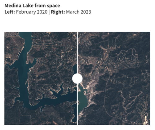
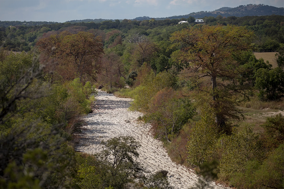
At the same time, surface water throughout South Central Texas is being sucked dry. The Guadalupe, Medina and Llano rivers have had historically low flows for this time of the year, while Canyon and Medina lakes are shrinking. And a number of popular natural swimming holes, such as Jacob’s Well in Wimberley, are shut down.
The aquifer’s current water level is at 635 feet, having dropped more than 15 feet in the past year and about 2 feet in the past 10 days. When the rolling average drops below 630 feet, it will trigger the Edwards Aquifer Authority — the government entity that regulates use of the aquifer — to call for Stage 4 water restrictions for suppliers who draw from the aquifer. Those restrictions mean reducing pumping by 40 percent from normal levels — a major cutback for some Hill Country communities, many of whom get all their water from the aquifer.
At the same time, surface water throughout South Central Texas is being sucked dry. The Guadalupe, Medina and Llano rivers have had historically low flows for this time of the year, while Canyon and Medina lakes are shrinking. And a number of popular natural swimming holes, such as Jacob’s Well in Wimberley, are shut down.
Paul Bertetti, the Edwards Aquifer Authority's senior director of aquifer science research and modeling, says this means the next few weeks are vital for the drought.
“It’s all about rainfall,” he said. “Even if we have normal rainfall during May and June’s rainy months, we should expect to see the same declines as we would during the summer. Unfortunately, at this point we have not even received a normal amount of rainfall. We’re about half of normal.”
Between January and March this year, the San Antonio area received 3.17 inches of rain. The average at this point of the year is 6 inches.
“If we follow this trend, we could see Stage 4 restrictions by early this summer,” Bertetti said. “If that’s the case, some communities will potentially be under a lot more stress this year.”
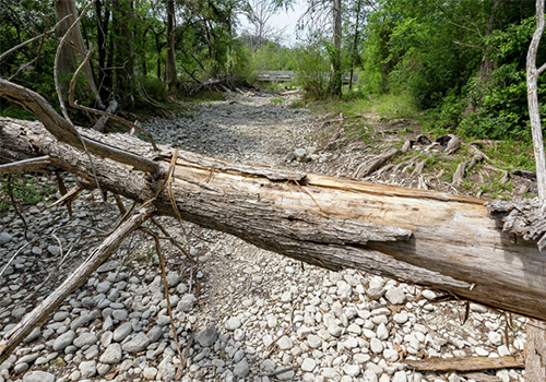
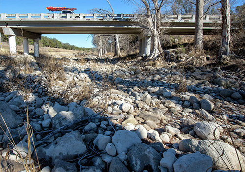
A dead tree lies across a completely dry Medina River Tuesday, April 4, 2023, near Gross Lane just east of La Coste. The river has had a flow rate of less than 1 cubic foot per second since March 25, according to the United State Geological Survey’s rive gauge in La Coste as shown on the agency’s water date website. The river’s flow has been below 5 cfs for much of the last six months, according to the website, and has been above 10 cfs only once since the second week of Sept. 2022. Median flow for the river is about 40 cfs.— William Luther/Staff
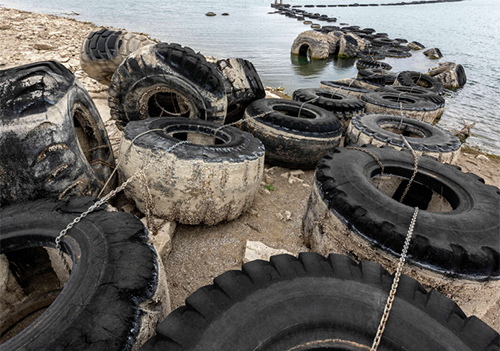
Large tires used as a breakwater stand high and dry Wednesday, March 15, 2023, at Canyon Lake’s Cranes Mill Marina as the lake dropped to 77 percent full Wednesday and 11.50 feet below conservation pool, according to the Texas Water Development Board’s Water Data for Texas website. That level approaches the reservoir’s lowest springtime level in over 30 years. — William Luther/Staff
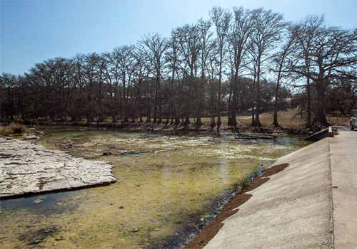
The Frio River is seen Feb. 15, 2023 in Concan. The river is flowing at just over 21 cubic feet per second in Concan according to the USGS’s water data website, but it goes dry before reaching FM 2690. Median flow for this time of year is three times the river’s current flow. —William Luther/Staff
The upper reaches of Canyon Lake are seen Wednesday, Jan. 25, 2023, near Comal County boat ramp #11 at Rebecca Creek. Canyon lake is more than 10 1/2 feet low and just 78.6 percent full, according to the Texas Water Development Board’s Water Data For Texas website. — William Luther/Staff
|
Gross Lane crosses a completely dry Medina River Tuesday, April 4, 2023, just east of La Coste. The river has had a flow rate of less than 1 cubic foot per second since March 25, according to the United State Geological Survey’s rive gauge in La Coste as shown on the agency’s water date website. The river’s flow has been below 5 cfs for much of the last six months, according to the website, and has been above 10 cfs only once since the second week of Sept. 2022. Median flow for the river is about 40 cfs. — William Luther/Staff
A car crosses the dry Guadalupe River at the Rebecca Creek Road crossing Jan. 25, 2023, as the river upstream from Canyon Lake remains abnormally low. Despite rains earlier in the week, the river remains far below its median flow rate in this area for this time of year of about 150 cubic feet per second and goes completely dry before reaching Canyon Lake. Prior to the rains, the USGS gauge just upstream from Rebecca Creek Road at FM 311 had been showing a flow rate of about 18 cfs in the river. The rains brought the flow up to 43 cfs for a few hours before the river began dropping again. —William Luther/Staff
The Frio River is seen Feb. 15, 2023, at the FM 2690 crossing just south of Concan. The river is flowing at just over 21 cubic feet per second in Concan according to the USGS’s water data website, but it goes dry before reaching FM 2690. Median flow for this time of year is three times the river’s current flow. — William Luther/Staff
A car crosses the dry Guadalupe River at the Rebecca Creek Road crossing Jan. 25, 2023, as the river upstream from Canyon Lake remains abnormally low. Despite rains earlier in the week, the river remains far below its median flow rate in this area for this time of year of about 150 cubic feet per second and goes completely dry before reaching Canyon Lake. Prior to the rains, the USGS gauge just upstream from Rebecca Creek Road at FM 311 had been showing a flow rate of about 18 cfs in the river. The rains brought the flow up to 43 cfs for a few hours before the river began dropping again. — William Luther/Staff
|
LAWATER RESTRICTIONS COULD GET TIGHTER
Since the Edwards Aquifer Authority created initial drought rules in 2000, restrictions have reached Stage 4 only twice, in 2014 and 2022.
Because of drought from 2011 to 2014, the authority implemented 89 days of Stage 4 restrictions -- which requires a 40 percent reduction of aquifer use -- from August to November. In 2022, after a year of severe drought, the area entered Stage 4 in August for a few days and again in October for a total of 24 days.
While there is always significant uncertainty, projections by the Edwards Aquifer Authority found that at normal rainfall, the aquifer could reach Stage 4 in August. But with less than normal rainfall, it could be as early as June.
However, San Antonio’s city-owned water utility, the San Antonio Water System, has its own set of regulations. Because SAWS also gets water from sources other than the Edwards Aquifer, the utility has gone only into Stage 2 watering restrictions during this drought. Stage 2 restrictions mean SAWS customers are limited to watering their lawns once per week.
Even if the Edwards Aquifer Authority enters Stage 4, it's not a guarantee that SAWS would also tighten its restrictions and move to Stage 3, which would limit watering to every other week. SAWS says it will analyze water supplies and customer demand every two weeks.
“The way the city ordinance is crafted is that Stage 3 is something that we start contemplating once the Edwards Aquifer triggers Stage 3, and if it appears that we’re not going to have enough apply to meet demand going forward, SAWS would recommend with the city manager to go into Stage 3,” said Karen Guz, vice president of water conservation at SAWS.
“The answer at the moment is no, not right now. We are not recommending" Stage 3.
Recently, the utility has been cracking down on water use violators. From Jan. 1 to last Wednesday, SAWS issued 1,136 citations and 734 warnings to residents for not following watering restrictions. A citation costs about $130.
On average, depending on family size, a home might use 5,000 gallons a month in winter and 8,000 gallons a month in summer. Houses with an automatic irrigation system might use as much as 15,000 gallons a month.
But when SAWS officials see a customer using 20,000 gallons or more, they know something is wrong. That is more water than 95 percent of the other SAWS customers.
“It would be premature to move to Stage 3 before we ramp up enforcement on Stage 2 through community messaging and communications,” Guz said. “We are watching the Edwards Aquifer constantly.”
On the other hand, communities outside of San Antonio might need to jump when the Edwards Aquifer Authority says jump.
Alamo Heights depends entirely on the Edwards Aquifer for water. Currently, the city is in Stage 3 watering restrictions, meaning watering once every other week. If the region enters Stage 4, the Alamo Heights City Council might hold an emergency session to consider other watering restrictions.
If the City Council "wants to incorporate more stringent conservation measures or whatever it may be, they can," said Patrick Sullivan, public works director for Alamo Heights. "But they'll be the ones to determine if we need to make any adjustments."
New Braunfels anticipates pulling about 6,000 acre-feet in total from the Edwards Aquifer this year. In the case of Stage 4, New Braunfels Utilities would determine if stricter measures were necessary, according to the city. Watering restrictions, landscape limitations and other activities would be examined on a day-to-day basis until Stage 4 could be lifted.
LAKES, WATERWAYS DRYING UP
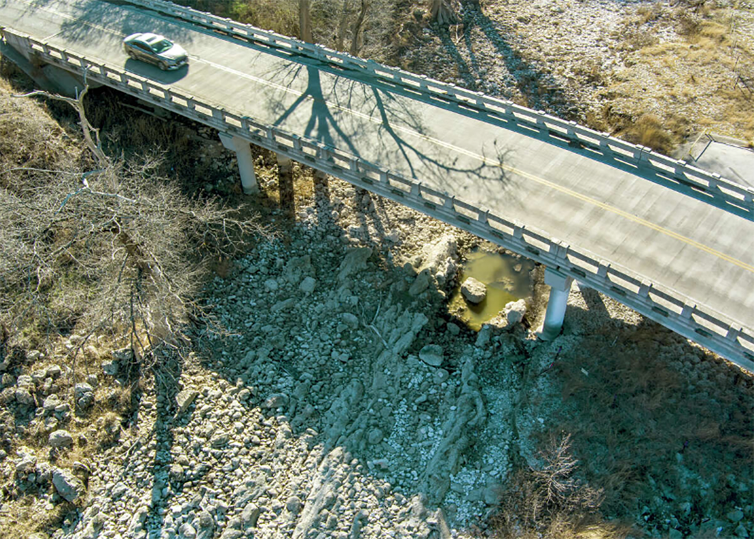
A car crosses the dry Guadalupe River at the Rebecca Creek Road crossing Jan. 25, 2023, as the river upstream from Canyon Lake remains abnormally low. Despite rains earlier in the week, the river remains far below its median flow rate in this area for this time of year of about 150 cubic feet per second and goes completely dry before reaching Canyon Lake. Prior to the rains, the USGS gauge just upstream from Rebecca Creek Road at FM 311 had been showing a flow rate of about 18 cfs in the river. The rains brought the flow up to 43 cfs for a few hours before the river began dropping again. — William Luther/Staff
For nearly two years, the United States has been under the influence of La Niña, a global climate pattern that causes an increase in drought and heat throughout the South. The weather has since shifted, however, and neutrality has taken over.
Neutral means normal patterns, such as more typical heat and rainfall through the spring and summer. This would be better for San Antonio’s drought, but not good enough. El Niño, a weather pattern that brings rain and colder than average temperatures to the southern U.S., could increase the amount of precipitation, said Bertetti of the Edwards Aquifer Authority. However, climatologists don’t foresee El Niño activities until fall.
Last year, San Antonio was 20 inches below normal precipitation – meaning it will take a lot of water to bounce back from the drought and the Edwards Aquifer region should expect drought restrictions for the entire year. It also means the rivers, creeks and lakes will continue to struggle.
Of the 306 creek and river gauging stations in the San Antonio area, 34 percent are below normal and 22 percent are well below normal as of March, said Doug Schnoebelen, branch chief for the South Texas U.S. Geological Survey. Both the Guadalupe River Basin and the San Antonio River Basin are of concern.
Adequate flows in rivers, creeks and lakes are crucial for wildlife that depend on the aquatic ecosystem, according to experts. Without enough water, fish will compete for oxygen as the water levels shrink and harmful algae blooms and bacteria growth can form in stagnant areas. Some aquatic species can adapt to low flow and move to areas with higher flow, but other species, such as mussels, are too slow to move and will die out. Animals will generally be able to bounce back after the flows increase again, but in the case of an incredibly low flow event, some species may be in more trouble.
Low water flow also affects local economies and businesses. Tubing operations could go out of business for an entire summer, or local lakeside restaurants could see a decrease in customers. In the Medina Lake community, lake view property taxes are the same even without a lake and Realtors are selling on the prospect of future water.
“If we don't get rain this spring, it will be a missed opportunity for these creeks and rivers,” Schnoebelen said. “And going into the summer usually doesn’t look good because of the high heat, high humidity and high evaporation rates. It takes a lot of rain to recharge these streams and then to recharge the aquifer.”
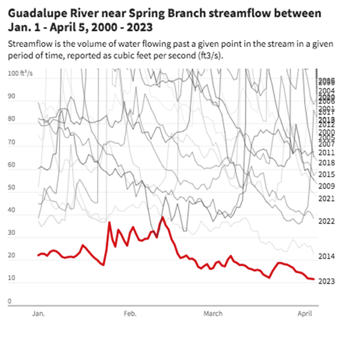
Based on 40 years of data, the Medina River in Bandera is at its lowest flows in history. The average water flow is 139 cubic feet per second. As of last Wednesday, the flow is 5.81 cubic feet per second. Based on 32 years of recorded data, the Guadalupe River just north of San Antonio is at 1.63 cubic feet per second, which is the lowest it has ever been. Prior to this year, the record low was 1.73 cubic feet per second in 2014. A cubic foot of water is about the size of a basketball.
“That’s the thing about Texas is we have really high water flows and then really low water flows,” Schnoebelen said. “Right now, we’re in a drought. Next year, we could be flooding.”
The last time creek and river levels were this low was in 2014, during the years-long drought in South Central Texas. Still, last year’s lack of precipitation beat out that year and every year since 1917. Medina Lake, a reservoir about 50 miles west of San Antonio, is at 5.3 percent of capacity. It dropped about 16 percent in a year because of irrigation pumping and the drought. The last time the levels were that low was in 2015.
Canyon Lake, a reservoir north of San Antonio, is at 76.3 percent capacity, having dropped 20 percent in the past year. If the lake drops an additional 5 feet, it will reach its lowest levels in the past 50 years.
“This rain we’ve gotten recently is maybe enough to keep the grass green, but it’s really not enough for our streams or our reservoirs or our aquifer,” Schnoebelen said. “That’s what we need.

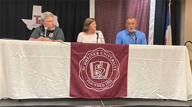
Dave Mauk, Tara Bushnoe, Benedicte Rhyne. Photo courtesy of Hill Country Alliance.
Recording: How the ongoing drought impacts the Hill Country
On February 22nd, Schreiner University, Hill Country Alliance, and Texas Public Radio hosted the 2023 Texas Water Symposium. The panel was focused on how the ongoing drought impacts the Hill Country, and included Tara Bushnoe, General Manager of the Upper Guadalupe River Authority, Dave Mauk, General Manager of the Bandera County River Authority and Groundwater District, Benedicte Rhyne of Wine Country Consulting, and Bob Barker of C&M Precast. You can listen to a live recording of the panel here.
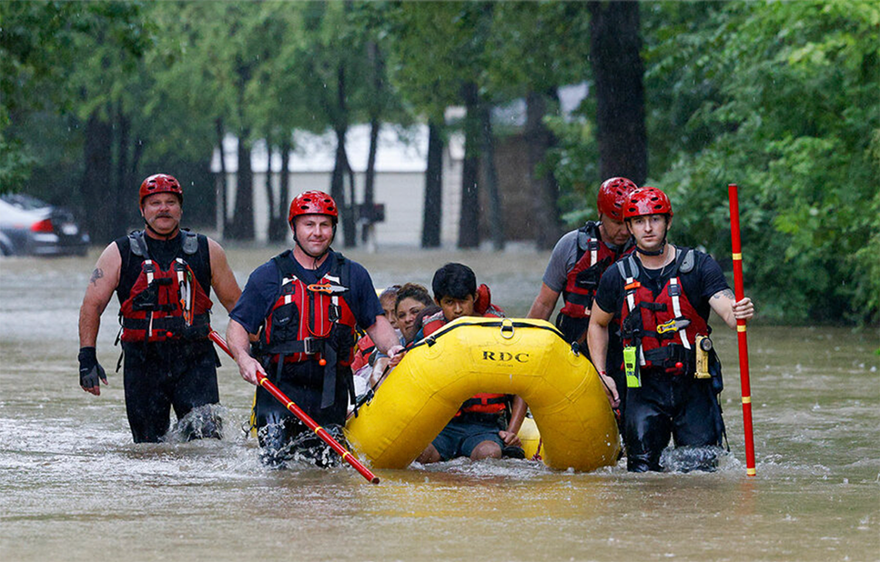
Members of the Balch Springs Fire Department bring a family of four by boat to higher ground after rescuing them from their home on Forest Glen Lane in Balch Springs, Texas on August 22, 2022. Amid severe drought in much of Texas, recent weeks have also seen damaging rains in parts of the state. Elîas Valverde II, The Dallas Morning News/AP
Heat. Drought. Fires. Floods. Texas grapples with a new era.
By Henry Gass, Xander Peters
August 31, 202
August 31, 202
|
ZAPATA, SMITHVILLE, AND GALVESTON, TEXAS
When engineer Manuel Gonzalez moved back to his hometown of Zapata 20 years ago, the Texas community was in a major local drought. “It was their challenge [then]. It’s my challenge now,” he says. Standing by the reservoir that serves as the town’s only water source, he shows the modest solution he’s been helping to build: |
A small structure of mud and rock, stretching a few feet into the Rio Grande-fed Falcon Lake Reservoir. At its edge he can pick up cellphone service from Mexico. More important, from it county pumps can access 15 feet of water – compared to 3 feet near the shoreline.
His effort is part of a transformation underway in a state that is feeling effects of climate change like never before |
WHY WE WROTE THIS
While climate change has not been a top political concern in Texas, it is increasingly emblematic of America’s climate change experience. From heat to damaging rains, this summer looks like a pivot point.
While climate change has not been a top political concern in Texas, it is increasingly emblematic of America’s climate change experience. From heat to damaging rains, this summer looks like a pivot point.
|
Almost every corner of the state has been experiencing extreme heat, and, until recently, often no rain too. These patterns of heat and drought aren’t limited to Texas, but the trends here are noteworthy. The Lone Star State, after all, ranks second only to California in population and is among the fastest growing states. It’s a linchpin of the U.S. economy, from energy to tech. And as a solidly Republican red state, it’s a place where evolving views toward climate could have outsize political effects. Already attitudes have been shifting. The share of Texans who believe climate change is currently harming people in the United States has risen from 50% in 2018 (slightly below the |
national average in that year) to 60% last year (just above the national average), according to Yale Climate Opinion Maps. This summer may be a preview of what scientists say could become normal conditions for the state. By 2036, Texas’ bicentennial year, there will be nearly twice as many 100-degree days as there are today, according to a study last year by Texas A&M University and Texas 2036, a nonprofit, nonpartisan policy organization in the state. Droughts are expected to become more severe, as are extreme rainfall events. Meanwhile, population growth is projected to accelerate.States has risen from 50% in 2018 (slightly below the national average in that year) to 60% last year (just above the national average), according to Yale Climate Opinion Maps. |
SOURCE: National Weather Service | Jacob Turcotte/Staff
|
But in the face of these challenges, Texans have been demonstrating resiliency and innovation. From connecting local water services, to adapting the state’s water plan, to cooperating with a nationwide wildfire response network, the state is working to adapt to, and prepare for, a climate change-altered future.
RESPONDING TO SEVERE DROUGHT For almost a year, almost all of Texas has been in drought conditions, much of it extreme. In mid-August, 99% of the state was experiencing “abnormally dry” conditions, according to the U.S. Drought Monitor, with over 97% experiencing the two most severe categories of drought. If the drought persists, experts say it may rival 2011, the worst single-year drought recorded in state history. In Zapata, the community of 14,000 has been caught between the Texas drought and a decadeslong drought in northern Mexico. Now the old Highway 83 is visible, 70 years after it was submerged by the Falcon Lake Reservoir. Javier Santiago (left) and Manuel Gonzalez survey the Falcon Lake Reservoir near the old Highway 83. The highway is normally underwater, but extreme drought this year has revealed the bridge, and threatened the community's only source of water.The structure Mr. Gonzalez helped build is just one solution. The community has also interconnected four local water providers so they can share resources. In early August, they announced an agreement between U.S. and Mexican officials to dredge sections of the reservoir and increase water depth. And Mr. Gonzalez, who runs a private engineering firm in south Texas, has been commissioned by the county to study potential secondary sources of water, including reusing wastewater. “We’re not there yet, but we are starting to look.” That seems to be the trend. The 2011 drought was thought to be the kind you get twice a century. “We’re having a drought [now] that looks very similar a mere 10 years after that 2011 drought,” says Robert Mace, a professor at |
Texas State University and executive director of the Meadows Center for Water and the Environment, in an interview earlier this month.
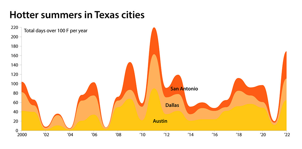
“We’ll be seeing drought conditions become a new normal for the state.” TRIPLE-DIGIT TEMERATURES ON THE RISE Heat and drought go hand in hand. As surface temperature increases, so does evaporation, and soil and foliage struggle to retain moisture. The extreme heat this summer has been especially keen in Texas’ major cities. Both Austin and San Antonio had their hottest May on record, followed by their hottest June on record, followed by their hottest July on record. Simultaneously, there has been very little rain. San Antonio is experiencing its worst year on record for rainfall. The Austin and Dallas areas went 52 and 67 days, respectively, without rain between June and August. This is partly due to an ongoing climate pattern known as La Niña. This cyclical pattern sees cooler than normal surface temperatures in the equatorial Pacific Ocean push rainfall and cooler temperatures away from the southern U.S. While this La Niña has been relatively mild, according to Dr. Mace, it has also been long – projected to last for a rare third consecutive winter. It’s unclear how climate change will affect La Niña, but it’s “very likely” that rainfall variability will significantly increase in the latter half of this century, according to the Intergovernmental Panel on Climate Change’s 2021 report. This summer Texas has had a preview of what that could look like. A few weeks after snapping its 67-day rainless streak, Dallas experienced what’s been called a “one-in-a-thousand-year” flooding event. Over 9 inches of rain fell in 24 hours – more rain than the area typically sees in a whole summer – and caused as much as $6 billion in damages, according to an estimate from AccuWeather. |
SOURCE: National Weather Service
|
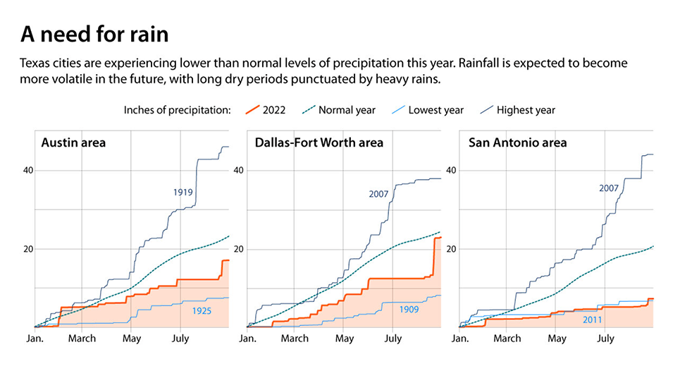
The Texas 2036 report on future climate changes in the state “not only pointed to increased future drought severity, but paradoxically a likely increase in future flood events,” says Jeremy Mazur, senior policy adviser on natural resources at Texas 2036.
The state’s surface temperature is predicted to be 3 degrees hotter by 2036, he adds. “What we’ll [then be] seeing is stronger peaks and longer valleys with regards to rainfall.” |
WILDFIRES GET HARDER TO CONTAIN
One area where Texas – and the country – has shown great resilience and resourcefulness is in combating the growing threat of wildfire. No two fire seasons are the same, but this year’s has been the busiest for Texas since 2011, with over 8,800 wildfires burning over 630,000 acres across the state. And risks are projected to grow as the state becomes hotter and more populated. Assistance from thousands of firefighters from around the state and country, coordinated through a national interagency network, has helped minimize the recent damage |
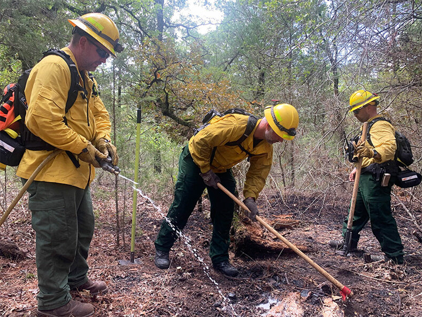
Jimmy McDonald (from left), John Jopling, and Tim Shillern of the Nacogdoches Fire Department extinguish a smoldering log while working on the Pine Pond Fire. Effective coordination between agencies inside and outside Texas has helped limit damage from wildland fires during one of the driest years on record in the state. Henry Gass/The Christian Science Monitor
|
Earlier this month, 56 of those firefighters gathered near Smithville, an hour west of Austin, to prepare for another day fighting the 700-acre Pine Pond Fire.
The previous day brought the county’s first significant rain in 52 days, but because it has been so dry, firefighters spend the morning patrolling fire lines for hazards that could reignite. They drive or walk over the charred landscape looking for “snags” – dead, standing trees that could be smoldering on the inside – and sniffing the air for “new” smoke (more pungent than “old” smoke). |
Around noon, as the sun begins to pierce the clouds, four men from the Nacogdoches Fire Department hack their way toward a smoking log deep inside a section of unburned trees, surrounded by dry pine needles and leaves. It’s this kind of hazard they’ve been extinguishing all morning.
The men primarily fight structure fires, but in a normal year they go on one to three wildland fire deployments. This year they’ve had one or two deployments each month. They make short work of the log – scraping off the ash and dousing it in water – and head back out to look for the next problem |
SOURCE: First Street Foundation's 5th National Risk Assessment, National Interagency Fire Center, Austin American-Statesman
|
Wildfires “are becoming more problematic to try to keep within the [containment] line,” says Steve Willingham, a resource specialist with the Texas A&M Forest Service and the senior incident commander for the Pine Pond Fire.
Yet wildfire response shows that statewide resources – nationwide resources, even – can be harnessed effectively when there’s a will to do so. “It keeps guys alive,” says Mr. Willingham. “It keeps people safe.” FLOODWATERS AND NEW DEFENSES The hope for rain varies by region in Texas. Travel east from dry Central Texas to the Gulf Coast’s emerald-green waters and |
it’s the persistent threat of flooding that grips researchers attempting to better understand the region’s future.
In August 2017, Hurricane Harvey dumped trillions of gallons of rainfall across metropolitan Houston and rural southeast Texas. The storm amounted to the second-costliest natural disaster in U.S. history, with $125 billion in damages – and a 2020 study in the journal Climate Change estimated that at least $30 billion of that was “attributable to the human influence on climate.” It’s not just changes in the atmosphere that make climate change costly. It’s also the built environment, says Samuel Brody, a professor at Texas A&M University at Galveston and the director of the Institute for a Disaster Resilient Texas |
SOURCE: National Oceanic and Atmospheric Administration | Jacob Turcotte/Staff
|
Focusing on the forces of nature, he says, “misses the whole idea of parking lots and rooftops and roadways and all this runoff we’re creating in downstream communities.”
In response, the institute recently launched a state-funded two-year project called Digital Risk Infrastructure Program, or DRIP. It partners with underserved Texas communities to solve flooding problems through data and analytical techniques. The upshot: Communities like tiny Premont (an early DRIP partner, population 2,500) tell their flood stories, which inform the project’s solutions for mitigating future risks. Among the state’s needs is defending against rising seas as well as heavier rains. Most ambitious among Texas climate-adaptation proposals is the proposed Dutch-inspired “Ike Dike,” named after the devastating 2008 hurricane that wiped out |
roughly 60% of structures on nearby Bolivar Peninsula and threatened Houston-area transportation routes. It was recently approved by Congress but funding remains to be approved.
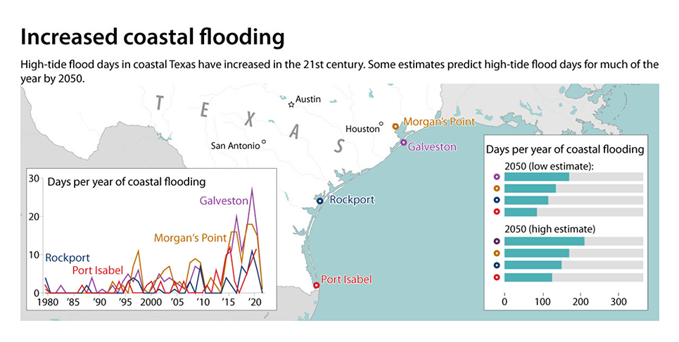
Even if the dike system is built, big risks would remain. Galveston Island, for example, is gradually sinking even as sea levels also rise. Twenty years ago, Galveston witnessed roughly three annual high-tide flood days; last year, there were 14. By 2050, the island is projected to experience 170 such events per year, according to the National Oceanic and Atmospheric Administration. “Nuisance flooding is going to start shutting down businesses,” says Bill Merrell, a marine sciences professor at Texas A&M University at Galveston, also a planner behind the Ike Dike. “If a parking lot’s occupied a third of the year with water, you’re not going to be able to function. You’ll have to adapt in some way.” |
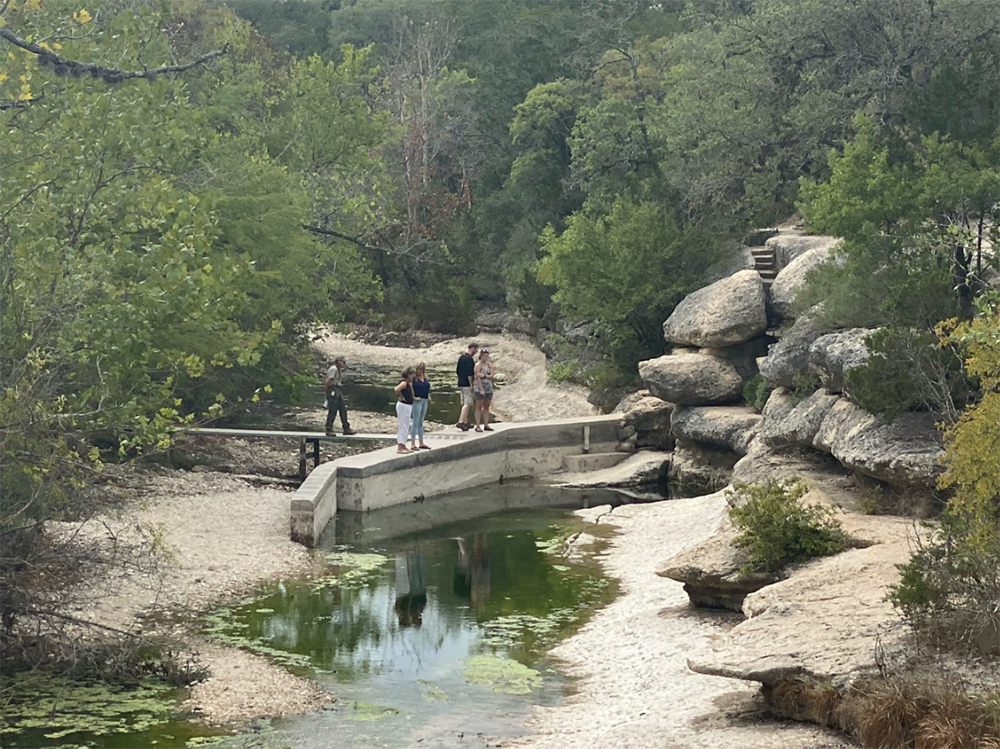
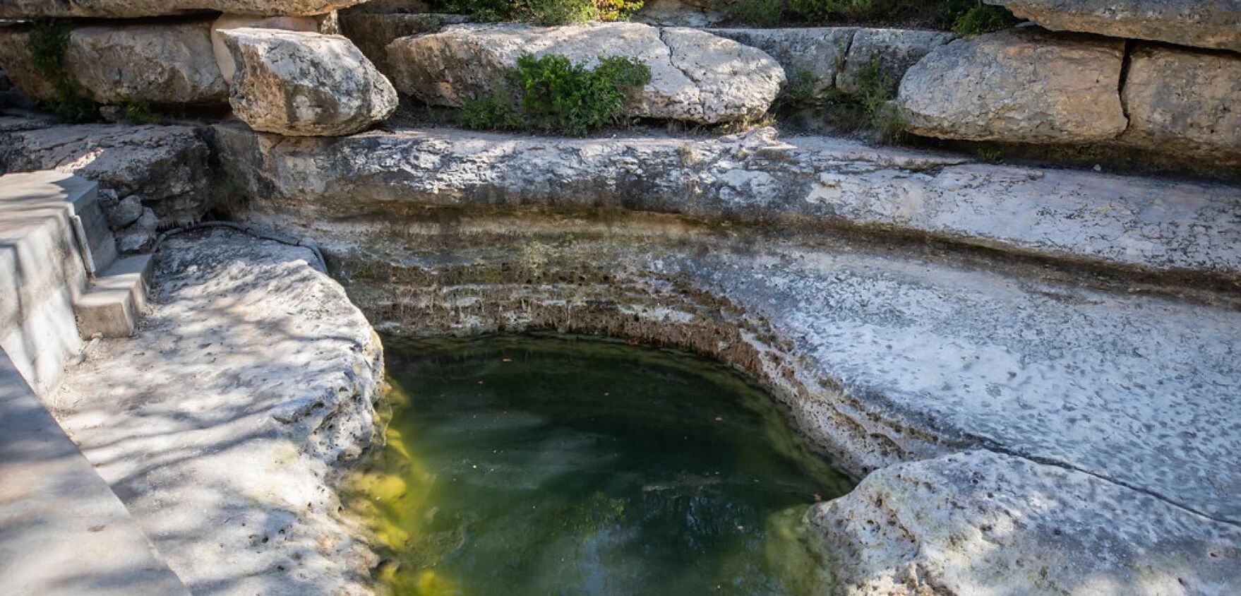
Jacob's Well by David Baker, 8/23/22
What Does Drought Recovery Look Like?
By Robin Gary
August 2022
August 2022
|
Over the past week, Wimberley received between 1.5-2 inches of rain. It's a refreshing change to the persistent hot, dry weather this summer. Richard Shaver, Director of the Wimberley Parks and Recreation Department, asked a wise question: "What does recovery look like?" With Jacob's Well basically not flowing (see photo by David Baker above, taken 8/23/22), sections of Cypress Creek are completely dry. There is no inflow or outflow downstream at Blue Hole. Monitor wells are at record lows, and many well owners are having to rely on hauled water.
|
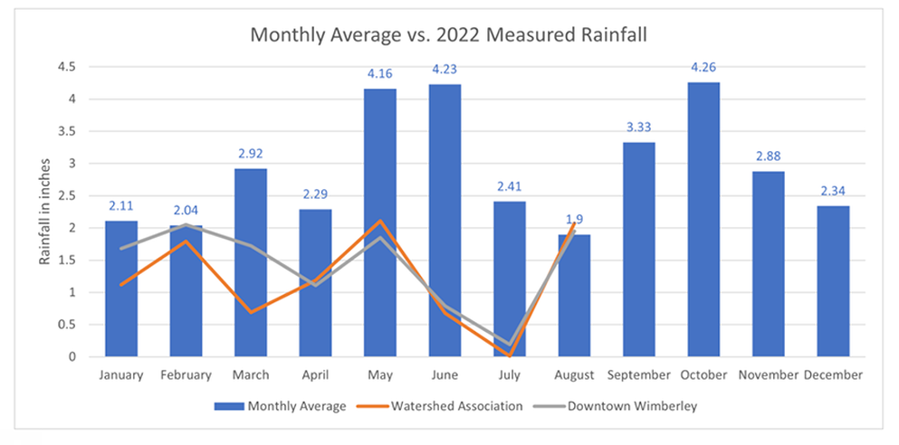
So how much rainfall would it take to return to non-drought conditions? Central Texas normally receives 33 inches a year with 22 inches coming by the end of August. As of today (August 26th), there have been 9.73 inches of rainfall at the Watershed Association office near Jacob's Well, and 11.34 inches in downtown Wimberley (Water Monitoring page). Depending on how much rain falls over the last week in August, there will still likely be a substantial rainfall deficit.
|
|
The prolonged hot and dry conditions have affected soil moisture, groundwater storage in aquifers, and flow from springs and creeks, which all have different response times to rainfall. Dry soils will likely soak up the first inch or two to the benefit of trees, grasses, and plants. After soils are saturated, they'll allow runoff to fill creeks and rivers, which funnel water into the groundwater system through karst features like caves, fractures, and sinkholes. Water levels in the Middle Trinity Aquifer in western Hays County will recover more quickly than the Lower Trinity Aquifer, which is deeper and has a confining layer that generally separates the two aquifers. Once water levels in the Middle Trinity Aquifer rise above spring elevations, spring flow will increase and supply needed baseflow to boost flow in streams like Cypress Creek and the Blanco River. Once Jacob's Well reaches a 10-day average above 6 cubic feet per second, the Hays Trinity Groundwater Conservation District will remove the drought declaration.
|
The simple answer to what drought recovery looks like is about 8-12 more inches of rain--hopefully not all at once--to get back to the average for the year. The USGS, groundwater conservation districts, and Watershed Association staff will be tracking rainfall, flow, and water levels closely to monitor drought recovery (hopefully)! There's no doubt that some rain is better than no rain! This week has been a good start on the road to drought recovery, but it will be a long road to bring groundwater storage, sustained spring flow, and creek flow back to healthy levels.
Please continue to conserve. Coordinated water conservation is key to preserve groundwater availability, spring flow, and water supplies. |

The Medina River remains dry because of the extreme drought affecting the Hill Country near Bandera. Credit: Nick Wagner / San Antonio Report
Drought as Catalyst: Hill Country Residents Seeking Greater Protections for Trinity Aquifer
By Lindsey Carnett
August 21, 2022
August 21, 2022
|
Kathleen Tobin Krueger stood on a low cliff last week, looking down on her family’s ranchland.
Below her lay an expansive field laden with smooth white rocks, trees with exposed roots growing between them. There should be a full, flowing river here — there usually is a full, flowing river here — the Medina River. Krueger stepped back from the cliff’s edge shaking her head, looking distressed. “In my whole life, I’ve never seen it like this,” Krueger said. Her family has owned the 700-acre Tobin Ranch in Bandera County for 75 years.Kathleen Tobin Krueger stood on a low cliff last week, looking down on her family’s ranchland. |
“It’s not even a mud puddle; usually it’s clear, flowing with water and lush beautiful green banks. Now it’s just white stones, laying there like bleached bones.” The former New Braunfels councilwoman and wife of the late U.S. Sen. Robert “Bob” Krueger shook her head again.
Krueger worries about the wildlife. Where are the deer and the birds getting water? She worries about their cattle. Fresh grass and clean water are getting more difficult for them to find. Krueger and the Tobin family aren’t alone in their concerns. |

Kathleen Tobin Krueger drives with her brother Patrick Tobin through the dry riverbed of the Medina River near Bandera on Saturday. Credit: Nick Wagner / San Antonio Report
|
Across Central Texas, families that depend on private wells are finding they’ve dried up — some for the first time. Ranchers are struggling to tend to water-dependent crops and to animals that can drink thousands of gallons of water a week.
While residents within San Antonio city limits who depend on the San Antonio Water System have been able to live life pretty normally this summer due to SAWS’ water diversification efforts, those living in rural areas in and around Bexar County are growing increasingly worried by the severity of the ongoing drought. Water security has long been an issue of concern for Texas, but as the state population continues to explode, droughts are becoming more intense than they have been in previous years, experts say. And while one of Central Texas’ main sources of water, the Edwards Aquifer, is protected and regulated by the Edwards Aquifer Authority, other important water sources in the region are not, or are only protected at the individual county level, despite spanning multiple counties. |
Calls to safeguard the Trinity Aquifer with similar protections that the Edwards enjoys have taken on increased urgency, as wells and tanks in the Hill Country run dry.
“[The Trinity Aquifer is] just more complicated, much more complicated, and there’s no authority for it like the Edwards Aquifer Authority that’s come through and really figured it out,” said Jack Oliver, a local geologist, cave researcher and a board member of Preserve Our Hill Country Environment. WILDLIFE ARE STRUGGLING Krueger and her brother Patrick Tobin have never been able to drive their ranch all-terrain vehicle straight up the riverbed as they can now. During a recent outing, the brother-sister pair stopped to get out and look around. As they stood on the cracked dry clay normally at the bottom of the Media River, they were dwarfed by several of the oaks and ash trees on the river’s edge. Fish bones littered the ground like confetti at some bizarre party; dozens of skulls and spines still intact lay next to each other in what must have very recently been a shallow pool of water. |
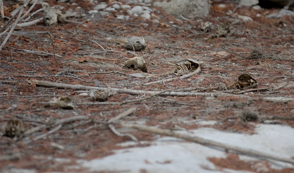
Fish carcasses remain scattered about the dry riverbed of the Medina River near Bandera on Saturday. Credit: Nick Wagner / San Antonio Report
|
Another quarter mile down, buzzards lined the side of the river bank next to one such remaining pool. The small oasis was green and cloudy. Frogs flitted about everywhere along the stagnant water’s edge.
Usually, the deer, birds and fish have plenty of clean flowing water to drink and swim in the Medina River, Krueger said. She’s worried particularly for the endangered bird species that pass through their ranch annually. Krueger has good reason to be — extreme drought can be particularly difficult on Texas wildlife, said Kelly Simon, an urban wildlife biologist with the Texas Parks and Wildlife Department. While much of Texas wildlife has evolved to survive drought, aspects that make modern drought particularly stressful on native Texas animals include human population growth and development, and the moving in of competitor species, such as axis deer, which compete with white tails, and red fire ants, which compete with native pollinators like bees, Simon said. “We used to say that wild types of Texas wildlife and plants are used to extremes; it’s kind of what makes Texas Texas,” Simon said. “Unfortunately, these days, it seems like the extremes are becoming normal — and so wildlife are experiencing a really difficult time.” |
THE HAY AND THE HERD
As Tobin skirted around the edge of the ranch, a nearby black cow started walking toward him and Krueger. “She probably thinks we have some food on us,” Tobin said as he passed her. The Tobins keep about 30 cattle and 25 calves on the ranch, Tobin said. Keeping them fed and watered has been an ordeal this summer, he said. The drought has caused lower hay yields than in previous years, Tobin said, making it more expensive to feed their herds. The scarcity of hay this year is also due to inflation, said Cooper Little, executive director of the Independent Cattlemen’s Association of Texas. While drought is nothing new for Texas farmers, Little said many ranchers were unable to buy good fertilizer this year due to its high cost. That resulted in less hay being grown and harvested just as the drought hit, he said. “Probably the main thing making this worse is that it was the perfect storm,” Little said. “Folks who could have hayed this year couldn’t fertilize their pastures and decided not to hay. That coincidentally fell on a year we went into drought. |

Dry farmland in southern Bexar County can be seen as hay yields dwindle and prices rise. Credit: Scott Ball / San Antonio Report
|
While Tobin Ranch has been able to produce enough water for its cattle so far, Tobin said some of their neighbors have been less lucky. He and Krueger have heard of neighbors whose stock tanks and wells have run dry, he said.
Folks across the South have been selling off their cattle because they’ve become too expensive to maintain, he said. That, in turn, has oversaturated the market. More straws in the same cupIt’s not just farmers and ranchers struggling to draw water from their wells. Residents of northern Bexar County, Comal County, and surrounding rural areas have taken to social media to talk about their private wells running dry. Oliver said Hill Country residents have been reaching out to him in recent weeks asking how they can get water trucked out to their rural homes because their wells have run dry. Oliver lives in Comal County, where for the first time since 2014 — the tail end of the last major drought — parts of the Comal Springs have gone dry. Last weekend, the Edwards Aquifer Authority declared Stage 4 pumping restrictions for its permit holders due to concern for the springs, which provide habitat for threatened and endangered species protected under the Edwards Aquifer Habitat Conservation Plan. Bryant Harris, owner of Triple H2O, a bulk potable water delivery business out of Canyon Lake, has been working 12- to 14-hour days getting water to rural customers. Harris said he’s getting calls from residents who have lived on their land for 20 years and never had their wells run this dry. While the drought of 2011 was an equally busy season for Harris, he said this year’s drought started earlier and has been marked by hotter weather — this summer has seen roughly 60 days in triple digits. What’s making this drought particularly difficult, he said, is the amount of growth the area has experienced: “There’s just so many more straws in the same cup.” |
PROTECTING THE TRINITY
In the past, drought has acted as a catalyst in the protection of Central Texas groundwater. The creation of the Edwards Aquifer Authority can be traced to the 1950s drought of record, which didn’t end until 1957. In 1959, the Edwards Underground Water District was created to “conserve, preserve and protect” the Edwards Aquifer; however, it wasn’t given regulatory powers. In 1991, the Sierra Club filed a lawsuit against the U.S. Fish and Wildlife Service for failing to protect species covered by the Endangered Species Act. The lawsuit sought to require the federal agency to ensure minimum spring flows from the Edwards Aquifer to the Comal and San Marcos springs to protect endangered species living there. In 1993, a U.S. district judge ruled in favor of the Sierra Club, ordering that spring flows must be maintained. Born out of this ruling, the EAA officially launched operations in 1996. Now, environmental advocates and land owners in Central Texas are calling on state officials to add more protections to other aquifers, such as the Trinity. Preserve Our Hill Country Environment and Friends of Dry Comal Creek are seeking to get residents out in numbers to The Comal Trinity Groundwater Conservation District’s Sept. 19 board meeting to urge greater protections for the Trinity. A social media post by Preserve Our Hill Country Environment notes that drilling into the Trinity by developers and quarries is further endangering the aquifer’s security. There is definitely a need to further protect the Trinity Aquifer, Oliver said, in part because it produces at a lower rate and takes longer to recharge than the Edwards. Landowners reliant on wells that are now drying up are mostly from the Trinity rather than the Edwards. A Trinity Aquifer Authority, structured like the Edwards, would help as the region continues to grow and as climate change makes weather patterns and droughts more severe, Oliver said. |
Wikimedia Commons
‘The Easy Water is Gone’: Drought and Climate Change Strain Texas Aquifers
Some Texas aquifers have stopped flowing altogether, while the levels of others are drastically below normal levels.
By Jill Ament
August 1, 2022
August 1, 2022
|
With heightened concern over dwindling water supplies in communities all across Texas, many towns and cities have put in place their most strict water conservation ordinances.
Robert Mace, executive director and chief water policy expert for the Meadows Center for Water and the Environment at Texas State University, says the lack of rainfall and unprecedented heat has caused aquifers in Texas – as well as statewide reservoir levels – to drop to levels reminiscent of the drought between 2009 and 2015. Listen to the interview by clicking the article title or picture above or read the transcript below. This transcript has been edited lightly for clarity: Texas Standard: How would you describe water supply conditions across the state right now? Robert Mace: Well, with the lack of rainfall and some unprecedented temperatures, we’re seeing aquifer levels drop, and we’re also seeing our statewide reservoir levels drop somewhat reminiscent of the drought we saw from 2009 to 2015. You mentioned groundwater across Texas, support water supply in some very populated parts of the state. Thinking about the Edwards Aquifer, the Trinity Aquifer, the Ogallala Aquifer – how are our ground water resources doing right now? Well, in Central Texas, and particularly the Edwards Aquifer, it’s an aquifer that has a lot of caves in it and fractures. It’s very responsive to the weather and very responsive to drought, unfortunately. And so we’ve seen water levels drop in those aquifers and we’ve seen spring flows as a response also drop. So, for example, Jacob’s Well, which is fed by the Trinity Aquifer, has recently stopped flowing. And then we’ve also seen Las Moras |
Springs stop flowing. San Felipe Springs out in Del Rio, which is fed by Edwards Aquifer, has kind of the lowest levels of flow in at least 50 years. And we’re also seeing Barton Springs, and San Marcos Springs where I work, not reached historic lows, but going deeper into the drought levels and requiring people to cut back usage in order to preserve the spring flows and the endangered species that live in them.
What efforts would you like to see? I mean, besides the just regular conservation that folks can do, and being mindful of their water use. Are there bigger efforts that the state needs to make to preserve our water resources for years to come? I think there’s things that can be done on an institutional level to conserve water. So, for example, using the built environment as a water supply, capturing air conditioning, condensate, which we generate a lot in Texas, capturing rainwater, reusing the wastewater. There’s a school in Wimberley that we refer to as the first warm water school in Texas, where, by capturing rainwater condensate, doing onsite wastewater treatment, they reduced their water footprint from the Trinity Aquifer by 90%. The City of Austin has done some very neat things with the main library. Similarly they also reduced the reliance on Colorado River water for that building by 80% to 90%. And then Austin also recently revealed a building scale wastewater treatment plant where they’re treating the wastewater that goes down the toilets, sinks the urinals, a treating and bringing it back in to flush urinals and flush toilets, thereby creating more water savings. It sounds like that ought to be conversations that we’re having at a broader level at this point then. Yes, I agree. And with the Texas population almost doubling every 50 years and just the easy water is gone for the most part. And so we need to be more creative and more strategic about where our water supplies are coming in the future, not only to make sure that you and I have water, but also that there’s water for the environment as well. |
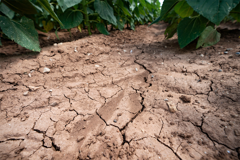
Cracked soil in a sunflower field near Snook, Texas, on June 8, 2022.
Laura McKenzie/Texas A&M University Division of Marketing & Communications
Heat Wave Deepens Texas Drought
A series of 100-degree days have created worsening conditions for livestock and crop producers across the state, Texas A&M AgriLife Extension Service agents report.
By Adam Russell, Texas A&M AgriLife Communications
July 14, 2022
July 14, 2022
|
A heat wave across the state is exacerbating the extreme drought conditions plaguing Texas agriculture.
Texas A&M AgriLife Extension Service agents and regional specialists around the state have reported a wide range of issues related to triple-digit temperatures and worsening conditions for livestock and crop producers. There are reports of poor forage and growing conditions throughout the state, including failed to stunted plants and lower yield expectations on crops ranging from sorghum, cotton, peanuts and pecans. Livestock producers in drier areas of the state have been weaning and marketing calves earlier and culling herds deeper than usual. There are also reports of herd consolidations occurring. The main factor driving higher and earlier cattle sale volumes is poor spring forage production from lack of rainfall and the high cost of supplemental feed. Hay supplies are tightening and cuttings have been well below average in most parts of the state so far. Declining surface water and poor water quality in stock ponds and tanks is becoming a wider issue for many producers. The extent of drought is driving local governments to implement restrictions on activities, including water consumption and outdoor burning. Burn bans have been implemented by county commissioners’ courts in 206 Texas counties as of July 11, according to the Texas A&M Forest Service. Irrigation water for agriculture is also falling under use-restrictions that limit applications to crops like cotton and pecans due to below-normal water levels in reservoirs and aquifers that desperately need runoff rainfall to recharge. Reagan Noland, AgriLife Extension agronomist, San Angelo, said the high temperatures and dry soil are leading to widespread crop failures even in some irrigated fields. There are no water restrictions on wells that pull from the aquifer for agriculture in that area. Noland said his area had good rain until mid-August last year but received no appreciable rain between late October and late May. When the area did pick up a two-inch rain around May 22, Noland said high temperatures and wind left muddy fields powder dry within days. “I hoped the rain in late May would provide a decent opportunity to plant cotton, but it wasn’t enough. Our subsoil moisture was too depleted for any planting moisture to persist,” he said. “Some irrigated fields looked OK, but most dryland crop acres never established at all, or seedlings burned up in the heat.” Heat Wave Delivers 100-Degree DaysJohn Nielsen-Gammon, state climatologist in the Texas A&M College of Geosciences Department of Atmospheric Sciences, said much of Texas has been experiencing above-average temperatures for months. South and Central Texas has been exceptionally hot this year, he said. San Antonio recorded 32 days over 100 degrees so far. The previous record for 100-degree days by this time of year in the city was 20 days in 2009. College Station has experienced 23 days with 100-degree temperatures, which is also more than ever recorded. |
Statewide, the Big Bend region has seen 78 days of triple-digit temperatures. Other notable locations with 100-degree days include Cotulla with 62, Laredo with 57, Del Rio with 48, Abilene with 45, and San Angelo with 44.
San Angelo is almost on pace with 2011 for 100-degree days. The city recorded 46 days over 100 degrees by this time and ended that year with 100 days over 100 degrees, he said. Multiple factors aligned to produce the high temperatures Texas is experiencing this summer, he said, including the early arrival of high temperatures. Locations in much of the state recorded record or near-record May temperatures that were above typical June average temperatures. Above-average spring temperatures and drought conditions compounded environmental effects on summer temperatures. The lack of moisture means there is less evaporative cooling, and more of the sun’s energy heats the ground which heats the air. Nielsen-Gammon said the water temperatures in the Gulf of Mexico are also well above normal. Most spring and summer air circulates into the state from the Gulf, and warmer conditions there translate into warmer air as it moves through the state. Heat waves like the one Texas is experiencing are related to weather patterns that create a dome of high pressure over the state or to the north, he said. The pattern prevents the flow of moist, tropical air and instead delivers air that has been sitting over the state or other hot areas around Texas. No Relief In SightNielsen-Gammon expects summer temperatures to remain above normal as soils continue to lose moisture and retain heat. “Unfortunately, the very hottest temperatures typically occur later in the summer, so off hand, I don’t see any relief in the future,” Nielsen-Gammon said. “It looks dismal for the next couple of weeks.” Nielsen-Gammon said a looming tropical disturbance could deliver some moisture to Louisiana and southeast Texas, but most of the state is likely to remain dry and hot. According to U.S. drought monitor archives, 100% of Texas experienced at least abnormally dry conditions with almost 72% experiencing exceptional drought conditions. The 2011 drought conditions peaked in October when 88% of the state was exceptionally dry while 97% of the state was in extreme to exceptional drought. Almost 98% of Texas is abnormally dry, but only 46% of the state is experiencing extreme to exceptional drought and 16% of the state suffering exceptional drought, according to the drought monitor. But it is a hard sell to tell many agriculture producers and farmers across Texas that 2022 has been better. Much of the state has received some scattered rain since January, Nielsen-Gammon said, but a few areas have received less moisture than in 2011. Corsicana, for example, has received less than 20 inches of rainfall since Sept. 1, compared to nearly 25 inches over the same period in 2010-2011. “There are definitely people who would take issue with anyone saying conditions are better in 2022 than in 2011,” he said. “For some, the impacts are going to be worse.” |

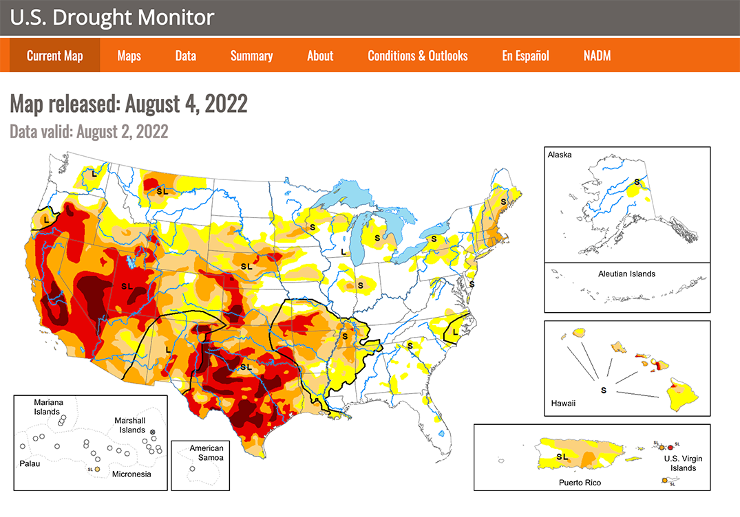
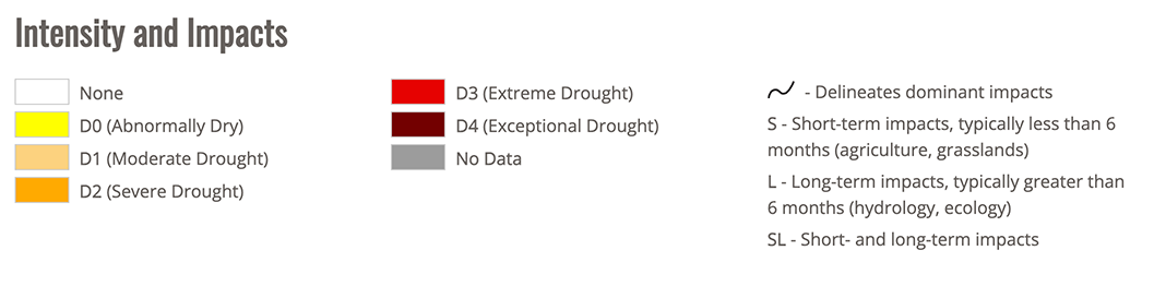
Drought Conditions in Central Texas Could Have Disastrous Impact on Area Rivers: Slowing River Flows Make the Water Quicker to Evaporate.
By Alan Kozeluh
July 7, 2022
July 7, 2022
|
SAN ANTONIO — Central Texas is seeing the worst drought conditions it has seen in a decade. It’s causing rivers to slow to a crawl and the impact of that could be disastrous.
“We definitely have some concerns with where the water level’s going to get too later in the year, if we don't start getting some level of consistent rain,” said Shaun Donovan, Environmental Sciences Manager at the San Antonio River Authority. There are places in south Texas right now where the flow of the river all but stops. “There's been reports of the Frio River is at 0.0 CFS, so it's not flowing at all right now,” Donovan said. “There was a lot of concerns and issues with the Guadalupe River, especially above Canyon Lake where they can't control the flow.” According to the U.S. Drought Monitor, most of Bexar County is in drought level D3, that’s out of four. Historically, this level, classified as Extreme Drought, has meant an increased risk of wildfires, severe loss of plant and |
wildlife, and very low river flows. The last time Bexar County was this dry was during the drought of 2011, when the entire state was at D4 – Exceptional Drought.
“Our treatment plants, whether it's, you know, most of that water is coming from SAWS, some of that water is coming from River Authority treatment facilities, helps mitigate those extreme ends of dry river conditions in our base and more so than a lot of other places.” Shaun Donovan said the treatment plants in their system puts the San Antonio River in a better place than other rivers in the state, but it’s still not a good place. “It's times like these, it's about mitigating loss,” he said. “Loss of habitat for fish, loss of fish themselves, loss of system productivity.” He says the drought has created a vicious cycle: slowing the water and making it easier to evaporate in the intense summer heat. He says it also lowers the level of oxygen in the water. “Fish need to breathe that dissolved oxygen. Muscles need to breathe that. Plants need dissolved oxygen,” said Donovan. |
STATE POLICYMAKERS HAVE OPTIONS:
- The state should require the Texas Water Development Board to consult with the State Climatologist on drought trends so that Texans have a better idea of the challenges we face.
- The State Water Plan should assess how well existing and recommended water projects would perform if Texas faced a drought of greater severity and duration, and also contemplate what emergency options could be implemented during such an event.
- We need to reassess how we are valuing water in Texas.
Is Texas Preparing for the Right Drought?
Texas’ strategy of planning for a repeat of the 1950s drought is no longer enough. While historic evidence identifies droughts that were longer and more severe than the Drought of Record, contemporary data points to a likely future of increasing drought severity.
By Jeremy B. Mazur and Todd H. Votteler
May 2022
May 2022
|
History is learned for the betterment of posterity. Despite this, we’re failing to apply key lessons for how we plan and prepare for drought.
In 1840, immediately after the storms of revolution swept across Texas, the plague of drought followed in their wake. Between the time of our state’s independence as a republic and the Civil War, a lengthy, withering drought wreaked havoc on the fledgling republic and young state. That drought was just one of several devastating droughts that have impacted our state over the past few centuries. Looking at paleoclimate records, Texas has endured multiple droughts of extraordinary duration and intensity. In addition to the drought of the 1800s, another major drought affected Texas during the early 1700s, when Spanish authorities founded a colonial outpost in San Antonio. While that drought was extraordinarily severe, it was dwarfed in length by the “Southwestern Megadrought” of the 1500s that spanned multiple decades and affected the entire American southwest including Texas. Since meteorological records began in the late 1800s, our state’s worst known one-year drought occurred in 2011. It was a searing ordeal, marked by record-high temperatures, dwindling water supplies, billions in agricultural losses and widespread wildfires. The drought that guides much of our state’s water planning, known as the Drought of Record, occurred in the 1950s. It scarred the state, both culturally and economically, and became the basis of our water planning. Texas’ State Water Plan prepared by the Texas Water Development Board anticipates future water needs if Texas were to endure a repeat of the 1950s drought. The planning process invites regional stakeholders to identify and prioritize water supply projects and conservation strategies that would, theoretically, meet the state’s needs should such a drought reoccur. Failing to take such steps, as a recent report by Rice University’s Baker Institute for Public Policy and Texas 2036 vividly demonstrates, invites economic devastation. The report foretells significant gross domestic product and job losses — cutting across the energy, agricultural, manufacturing and semiconductor industries — that shortages of groundwater and surface water will naturally trigger. |
Unfortunately, Texas’ strategy of planning for a repeat of the 1950s drought is no longer enough. While historic evidence identifies droughts that were longer and more severe than the Drought of Record, contemporary data points to a likely future of increasing drought severity. A report by Texas 2036 and the Office of the State Climatologist at Texas A&M University projects that rising average temperatures and greater rainfall variability will contribute to a future with more severe droughts.
Given this lengthy history and projected future, Texas needs to think differently about how we plan and prepare for drought. We can deduce that a drought worse than the Drought of Record will inflict greater economic damage on industries critical to our continued prosperity. FORTUNATELY, STATE POLICYMAKERS HAVE OPTIONS:
Droughts are part of the Texas experience. Our history offers a cautionary tale about drought as does the unfolding catastrophe in much of the Western United States, especially in California. There, an unprecedented megadrought has lowered water levels below intakes, threatened hydropower production and prompted curtailments of water for agriculture. California’s hardships could foreshadow a grim future for Texas unless we confront our persistent water vulnerabilities by mastering the lessons of past droughts and preparing for a future of greater drought extremes. |
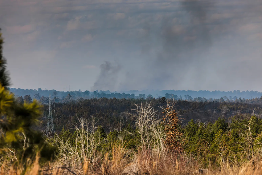
A prescribed burn in Bastrop State Park escaped its containment area and burned nearly 800 acres in January. Wildfires have erupted across Texas this spring as a deepening drought and record heat hammer the state. Credit: Jordan Vonderhaar for The Texas Tribune
Texas Drought Strengthens its Grip, Triggering Wildfires, Water Restrictions, and Crop Disasters
Hundreds of wildfires have broken out this spring. More than a dozen areas are under voluntary or mandatory water use restrictions, and more than 200 Texas counties have been designated as crop disaster areas.
By Erin Douglas and Emily Hernandez
May 25, 2022
May 25, 2022
|
Fueled by soaring temperatures and drought, hundreds of wildfires have already broken out across the state this spring. Since January, more than 400,000 acres have burned, more than seven times as many acres as the same period last year — but still far below the record-breaking drought and fire year of 2011. The fire risk has prompted 131 of Texas’ 254 counties to impose outdoor burn bans, according to Texas A&M Forest Service.
Weekend rains across much of Texas offered a break from the record-breaking temperatures, but experts said it wasn’t enough to blunt the drought. The National Weather Service forecasts the drought will expand in Texas through at least August. WATER SUPPLY WORRIES LAWMAKERS The lack of rainfall has also prompted at least 15 water utilities, mostly in the Hill Country, to issue mandatory water use restrictions this year, according to data reported to the Texas Commission on Environmental Quality.An increasingly severe drought now covers more than 90% of Texas, according to the U.S. drought monitor, affecting more than 16 million Texans and stressing ecosystems in nearly every region of the state. In West Texas, a wildfire has burned at least 27 homes and forced much of Taylor County to evacuate; it’s one of nine wildfires that firefighters battled to contain last week. In the Panhandle, the drought has devastated the wheat crop. In South Texas, the Rio Grande has run dry in some areas. Since September, average rainfall in Texas is less than 10 inches — the first time that’s happened since 1925, according to state climatologist John Neilsen-Gammon. “This is only the second drought where you have more than half of the state in extreme drought conditions,” Nielsen-Gammon said. East Texas has fared better so far, but the National Weather Service predicts that dry conditions could push further east by the end of this summer. The drought was prompted by La Niña, a natural Pacific Ocean cycle that impacts weather and typically brings dry and warm conditions to Texas, and its consequences have been accelerated by climate change. According to National Weather Service experts, the current pattern looks similar to 2010-11, when the last major drought wreaked havoc with the state’s municipal water supplies and agriculture yields. “The worst [recent] drought in Texas by far was in 2011,” said Aaron Treadway, lead forecaster for the National Weather Service in the Austin-San Antonio region. “We’re slowly creeping up there again.” Droughts are enhanced by climate change, which increases average temperatures and reduces soil moisture, causing crops to fail and reservoirs to drop. “There’s nothing that happens that isn’t affected by climate change,” said Andrew Dessler, an atmospheric sciences professor at Texas A&M University. Several metro areas across the state have broken century-old temperature records this month, prompting weather officials to warn the public to stay hydrated, avoid the sun, and check on relatives and neighbors who could be vulnerable to heat exhaustion. Temperatures recently exceeded 105 degrees in West Central Texas, including a swath of counties near San Angelo, while San Antonio last week recorded some of its hottest days ever for mid-May — including 101 degrees on Wednesday. |
Some reservoirs in the western half of the state are already stressed. At Medina Lake, which helps supply water to San Antonio, water levels have fallen to less than 20% of capacity, down from 36% a year ago. As of Friday, the state’s reservoirs were 79% full, according to the Texas Water Development Board. Typical storage levels in Texas are closer to 85% this time of year.
Underground aquifers, which are typically more resistant to drought, are beginning to decline in parts of the state as well. The Edwards Aquifer, a key water source for the San Antonio region, is nearly 20 feet below its normal levels for this time of year, according to the National Weather Service. More than a third of the state’s irrigation and livestock water supplies are provided by the Ogallala/Edwards-Trinity Aquifer, according to the Texas Water Development Board. The Panhandle-area aquifer has lost an average of more than 6 feet in the last decade, according to the High Plains Water District, and in some places the losses have exceeded 18 feet. A growing population needs more water, and state lawmakers are concerned that a statewide plan to develop new water sources won’t be sufficient. Sen. Charles Perry, R-Lubbock, said during a May 10 Senate committee hearing that the Texas Water Development Board appears to be planning around projects that are unlikely to be built quickly enough to provide more water for the growing state and called for more “innovative” projects, including desalination plants that could make seawater from the Gulf of Mexico drinkable. “The water plan has things in it that if we are truly honest today, aren’t going to happen,” said Perry, who chairs the Water, Agriculture and Rural Affairs Committee. “We have to start earnestly seeking out other options.” The plan calls for 23 new reservoirs to be built across the state by 2070 at an estimated construction cost of around $12 billion; a Texas Water Development Board staff member told Perry that it typically takes around 20 years to permit and construct a reservoir. “There’s pockets of this state that don’t have until 2070,” Perry said. “As the state is growing, the options get fewer and fewer every day.” MOST TEXAS COUNTIES RECEIVE CROP DISASTER DESIGNATIONS Soil moisture in most of the state is so low that crops are already failing or expected to be much smaller than usual even with the recent rain, said Jourdan Bell, a regional agronomist for Texas A&M AgriLife in Amarillo. “If you’re negative $100 and you get paid $10, that’s nice, but it sure didn’t get you out of your deficit,” Bell said. “In this drought, we are truly in a deficit.” More than 200 Texas counties have received crop disaster designations — which makes loans and other financial assistance available — from the U.S. Department of Agriculture due to extended drought conditions. The olive crop in several South Texas counties could be a near-total failure, according to experts at Texas A&M AgriLife Extension Service, and cattle ranchers have reported culling their herds as rangeland dries. In the Panhandle, at least 40% of the wheat crop, which is typically harvested in June, will likely fail this year, Bell said. The number of failed acres “is increasing by the day,” she said. Many Panhandle farmers have opted to plant cotton — which is more drought resistant — instead of corn, which is one of the primary crops for feeding livestock. “We have historically depended on irrigation from the Ogallala Aquifer,” Bell said. “But in recent years, we have seen the Ogallala Aquifer decline to a point where we can no longer meet the crop water demands.” |
Drought Is Back in Full Force
By Robin Gray
June 2022
June 2022
Springs and monitor wells in both the Trinity and Edwards Aquifers show significant drought impacts. Jacob’s Well spring flow average is less than 1 cubic feet per second (cfs). Daily fluctuations in spring flow are due to local effects of groundwater pumping.
Baseflow provided by Pleasant Valley Springs and Park Springs on the Blanco River is at the lowest recorded flow since the USGS monitoring site was established in 2016. Low spring flow translates to low flow in area creeks and rivers. The Hays Trinity Groundwater Conservation District has set a 30% drought curtailment in the Jacob’s Well Groundwater Management Zone and 20% drought curtailments in the remainder of the District to prolong availability of limited groundwater supplies.
Baseflow provided by Pleasant Valley Springs and Park Springs on the Blanco River is at the lowest recorded flow since the USGS monitoring site was established in 2016. Low spring flow translates to low flow in area creeks and rivers. The Hays Trinity Groundwater Conservation District has set a 30% drought curtailment in the Jacob’s Well Groundwater Management Zone and 20% drought curtailments in the remainder of the District to prolong availability of limited groundwater supplies.
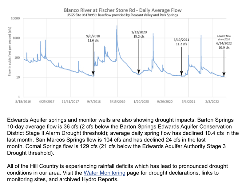
|
Edwards Aquifer springs and monitor wells are also showing drought impacts. Barton Springs 10-day average flow is 36 cfs (2 cfs below the Barton Springs Edwards Aquifer Conservation District Stage II Alarm Drought threshold); average daily spring flow has declined 10.4 cfs in the last month. San Marcos Springs flow is 104 cfs and has declined 24 cfs in the last month. Comal Springs flow is 129 cfs (21 cfs below the Edwards Aquifer Authority Stage 3 Drought threshold).
All of the Hill Country is experiencing rainfall deficits which has lead to pronounced drought conditions in our area. Visit the Water Monitoring page for drought declarations, links to monitoring sites, and archived Hydro Reports. May through September is considered the high-water-use season. For many homes, outdoor irrigation increases substantially. Most communities in the Hill Country are groundwater-dependent, so drought |
conditions are particularly troublesome for water supplies, recreation-based tourism, and springs and rivers. Please follow groundwater district drought restrictions and local water provider drought water use guidance. Limit outdoor irrigation and conserve water indoors. Identify and fix leaks. Conserve water to prolong water supplies until rainfall can replenish our aquifers. While we can’t control the weather, we can conserve water and look for innovative ways to use alternate supplies (like site-harvested supplies—rainwater and AC condensate) to lessen impacts of pumping. While each aquifer behaves differently, all groundwater is limited and deserves to be used wisely. For more information on native landscapes, rainwater harvesting, leak identification tips and more, visit the Home Owner Resource page.
No matter what area agencies call their drought declaration, coordinated water conservation is important to preserve groundwater availability, spring flow, and water supplies. |
The Trinity Aquifer
By Gregg Eckhardt
|
The Trinity Aquifer extends in a band through the central part of the State from the Red River to the eastern edge of Bandera and Medina counties, and the Trinity-Edwards Plateau Aquifer covers all or part of over 20 counties from Gillespie to the trans-Pecos region of west Texas. Together, they are the primary water source for most of the Hill Country. Most users in northern Bexar, Bandera, Kendall, Comal, and Kerr counties get their water from the Trinity. At the same time, all of Bandera, most of Kerr and Kendall, and large parts of Comal and Bexar
|
counties serve as drainage or catchment area for the Edwards Aquifer. So even though users in the Hill Country use a different aquifer they are caught up in Edwards Aquifer issues, especially with regard to restrictions on development or discharges that could affect the quality of water that eventually ends up as Edwards recharge. There is also growing evidence that hydraulic connections between the Edwards and the Trininity aquifers are more significant than previously believed, and this may eventually have additional implications for Trinity Aquifer use and management.
|
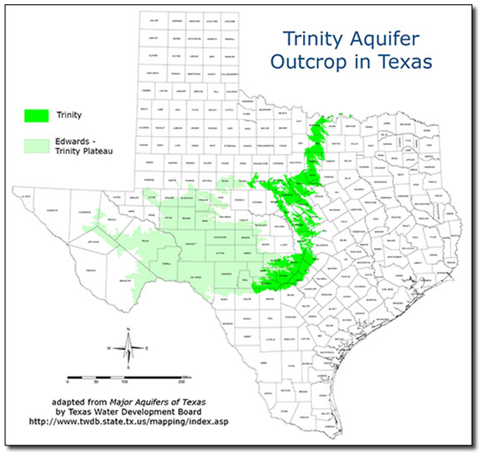
|
Unlike the Edwards, the Trinity Aquifer recharges very slowly. Only 4-5% of water that falls as rain over the area ends up recharging the Aquifer, and water also moves through the Trinity much more slowly than through the Edwards. The Trinity contributes a significant amount of water as recharge for the Edwards. Recharge to the Edwards can occur where the layers are juxtaposed by faults or, where the Trinity underlies the Edwards, by upwelling. A finite-element model built by Eve Kuniansky and Kelly Holligan in 1994 suggested that perhaps as much as 360,000 acre-feet per year enters the Edwards from the Trinity. A study in 2000 suggested this figure, which amounts to more than half of Edwards recharge, is probably too high, and placed the value at 59,000 acre-feet (Mace, 2000). An analysis in 2011 concluded that interformational flow is very difficult to characterize and measure, but it is probably more than suggested by Mace (Green, 2011).
There are actually several aquifers that make up the Trinity. The Trinity is a group of geologic deposits divided up into several distinct formations, and each formations is in turn comprised of several layers called members. In North Texas around Dallas-Fort Worth, the upper formation is the Paluxy. |
By the 1970s water levels in the Paluxy had been drawn down by as much as 550 feet, so many wells in that area have been abandoned in favor of surface water supplies. The Paluxy does not occur south of the Colorado River, where the upper unit is the Glen Rose formation. This is the formation that users in south central Texas are most familiar with, and it has also been overused in many places. It is comprised mainly of limestone that thickens toward the Gulf, and it is divisible into upper and lower members. Below the Glen Rose formation, the lower units of the Trinity Group are the Twin Mountains and Travis Peak formations. The Twin Mountains formation occurs in north-central Texas and is the most prolific of the Trinity aquifers. Toward the south in the Hill Country, the Travis Peak formation is made up mostly of sands, silts, conglomerates, and limestones, and it is subdivided into members as shown below. Most of these lower members of the Travis Peak formation have not been extensively used. Water quality in the Trinity Aquifers is generally much lower than in the Edwards and it is also more variable. For example, in north-central Texas waters in the Glen Rose are highly mineralized and are a source of contamination for wells drilled into the underlying Twin Mountain formation, but towards the south in the Hill Country the Glen Rose can yield moderate quantities of fresh water.
|
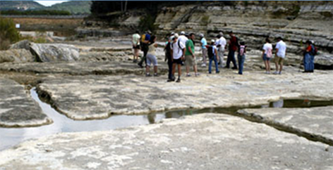
|
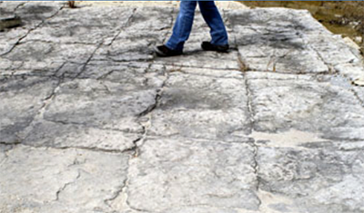
|
These photos, taken in 2007 in the newly formed Canyon Gorge, illustrate why drilling a well in the Trinity can be a hit-or-miss undertaking. On the left, notice how fractures in the limestone tend to form in straight lines and at right angles. These become solutionally enlarged and form well-defined underground conduits such as shown at right. They can be so geometric and regular they almost look like man-made irrigation trenches, but they are not. When drilling a well, you might hit one or several of these conduits, or you might not. If you don't, you end up with a dry hole. These conduits were exposed suddenly during the flood of 2002, not slowly by erosion, so they offer an especially instructive look at the typical underground structure (see the Canyon Lake section for more on Canyon Gorge)
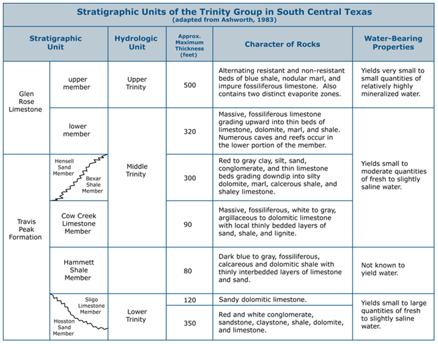
A recent model developed by the Texas Water Development Board projects steep drops in well levels over the next 50 years for large areas overlying the Trinity Aquifer (2). Already, many users have seen their wells go dry and are having to deepen them to search for more water. For many users, the model pointed out the need for regional planning and diversification of their water source. The cities of Boerne, Fair Oaks Ranch, and some other smaller Hill Country communities have already contracted with the Guadalupe-Blanco River Authority to receive water from Canyon Lake. You can retrieve a copy of the report here.
|
Exploding growth over the Trinity and dwindling supplies have stirred concern about regulation of this resource. In 1990, the Texas Natural Resource Conservation Commission designated the Trinity region to be a Priority Groundwater Management Area (PGMA), defined as an area where a critical water shortage is occurring or can be expected to occur in the next 25 years. Inclusion in a PGMA gives county officials some authority to regulate development over the Aquifer by requiring that developers prove there is water available before platting new construction. It can also aid in the formation of a groundwater conservation district, which would have taxing and regulatory power and could regulate well spacing and production. In March 1999, a group of
|
residents began outlining a plan to create such a district. In September 2000, the TNRCC scheduled a hearing to hear arguments for and against including the portion of northern Bexar county that lies over the Trinity in the Priority Groundwater Management Area (5). This area kind of slipped through the crack. It was not included in the PGMA originally because it was under the jurisdiction of the Edwards Underground Water District. But the EUWD was dissolved and replaced by the Edwards Aquifer Authority, which does not have authority to regulate the Trinity. On April 6 2001 the House Natural Resources Committee approved legislation to create a groundwater management district in northern Bexar county to oversee withdrawals in that area (6).
|
The Trinity is projected to be one of the most stressed aquifers in the State over the next 50 years, with large areas seeing steep drops in water levels. Spring-fed stock ponds such as this one may be in serious jeopardy.
SUNSET FOR THE TRINITY
|
In the late 1990s, the situation regarding rules and regulations for much of the Trinity Aquifer was much like what existed for the Edwards Aquifer prior to Senate Bill 1477, which regulates Edwards groundwater withdrawals (see Rules Section). The "rule of capture" still prevailed in the rest of the State outside the Edwards region, so there were few restrictions on using groundwater or drilling wells in the Trinity Aquifer. But lawmakers had come to recognize the rule of capture is basically an unworkable free-for-all, because it gives everyone unlimited rights to a finite resource. It is sort of like a circular firing squad. Even so, none had been willing to tackle the issue head on, and you can't really blame them.
In Texas, politicians who dare to suggest that private property rights are less than paramount are routinely placed on rails and escorted from town wearing tar and feathers. So in 2001, the Legislature punted by passing a law that makes it easy for property owners to form Groundwater Conservation Districts (GCDs) by petition. It gave such Districts the authority to regulate spacing and production from wells, and deemed GCDs to be the State's preferred method of groundwater management. This provided a politically correct frame of "local control" for pumping regulations while allowing lawmakers to avoid certain political doom. Since 2001, the number of such districts in Texas has more than doubled to almost 120 (in October 2011). All the Districts participated in a process in which local residents determined the "Desired Future Conditions" (DFCs) for their aquifer. A Desired Future Condition is a quantifiable future groundwater condition, such as a particular groundwater level, a level of water quality, or a volume of spring flow. Most of the time, the Desired Future Conditions will involve pumping limits. In April 2001, the first pumping limits for the Trinity were established by the Headwaters Underground Water Conservation District, which has the power to regulate withdrawals in Kerr county (8). The rules only apply to high-volume wells, mostly those used in irrigation. For wells that are capable of producing more than 25,000 gallons per day, the rules establish a cap of 137 gallons per day per acre of land for Middle Trinity Aquifer wells, and 178 gallons per acre per day for Lower Trinity Aquifer wells. Water planners and officials who imposed the rules felt the move was a bid to make the resource sustainable for generations to come. In May 2001, the election of Water District and City Council candidates who were most outspoken about protecting the Trinity was interpreted as a public validation of the new rules (12). In February 2000, the San Antonio Water System signed a contract to buy Trinity Aquifer water from the Massah Development Corporation. The company owns the Oliver Ranch, located west of US 281 just south of Bulverde Rd. Under the 10 year contract, the company drilled several wells to supply up to 4,500 acre-feet of water to San Antonio. SAWS extended pipelines to the point where it can accept the water, and will also maintain the wells and pay Massah $1 per 1,000 gallons of water, up to $3.25 million per year (1). In September 2000, the SAWS Board approved a contract to drill wells on another property nearby owned by BSR Inc.(4). Under this contract, SAWS may purchase about 1,500 acre-feet per year. In Spring 2001, several controversies erupted concerning the Trinity Aquifer and golf courses. Near Bulverde, developers applied for permits from the Southeast Trinity Groundwater Conservation District to drill two new wells and supply 400 acre-feet of water per year to their proposed Cibolo Cliffs Golf Course (7). Nearby residents who had to haul water in trucks to their property in the summer of 2000 when their wells went dry objected to the developer's plans (9). An engineering study suggested the golf courses' wells would not seriously draw down other wells in the area, but neighbors remained skeptical. In April 2001, the District voted to deny a permit that would have allowed the developers to drill two test wells to determine what the effect would be on neighboring wells (11). A second controversy in Spring 2001 involved creation of a tax district for a planned golf resort in Bexar county that partially overlies the Trinity Aquifer. Developers planned to turn almost 2,900 acres into a PGA Village with resort hotels, 3 golf courses, a conference center, retail stores, and low density residential development. A taxing district known as the Cibolo Canyon Conservation and Improvement District No. 1 would be a developer-controlled district with almost all the powers of a city to tax and use the revenues to pay for roads, water, and other infrastructure needs. Water would come from the San Antonio Water System and golf course irrigation would be partially accomplished by reusing wastewater, but there would also be two wells in the Trinity Aquifer that would eventually be used for part of the golf course properties. Some questioned the wisdom of giving developers powers of eminent domain and the power to tax to finance the infrastructure (10). By May 2001, both the Texas House and Senate had approved a bill to create the District, and it was signed by Governor Perry on May 23 (13,14). Details about how the development will be built were to be worked out between the city and the developers, since the property is within the extraterritorial jurisdiction of San Antonio. Although it started as a Trinity Aquifer issue, part of the development also lies over the Edwards Aquifer recharge zone, and by mid-2001 the issue had exploded into what would become one of the most bitter and divisive debates in San Antonio history. By July 2001, nine groundwater districts over the Trinity, including those in Comal, Kendall, Hays, Bandera, Blanco, Gillespie, Kerr, Medina, and Travis counties, had joined the Hill Country Alliance of Groundwater Districts. The Alliance began in 2000 as an informal way for board members of the various districts to share information and talk about common issues. Most members do not favor formation of a Trinity Aquifer Authority for the region, which would be similar to the Edwards Aquifer Authority and have the power to regulate and allocate pumping. Members favor local control and feel an Authority would put control of the water in the hands of water marketers and people who do not have the best interests of the community at heart. In 2001 the Alliance was awarded a $450,000 grant to install nine monitoring wells throughout its nine counties (15). On July 1, 2001, newspaper headlines reported a chemical plume beneath Camp Bullis Military Reservation had contaminated a small portion of the Trinity Aquifer and could pose a threat to the Edwards (16). Decades before, decontaminating fluid was poured over numerous vials of various chemical weapons and buried in trenches. It was thought the decontaminating fluid had broken down over time to form trichloroethene (TCE), which if ingested at high levels can cause a wide range of health problems from nervous system effects to coma and death. A 1999 report by hydrogeologist George Veni outlined several ways the chemical could migrate through the Trinity Aquifer and along fault planes and eventually reach the Edwards; but it also stated that contaminants would probably be diluted to less than drinking water standards by the time they got there. On July 2, 2001, the Texas Natural Resource Conservation Commission said the threat to the Edwards was "overstated" in the July 1 article, and spokesman Patrick Crimmins said there is no evidence the plume could spread into the Edwards (17). The military has drilled a number of monitoring wells around the site and is planning a thorough cleanup. An undetermined number of private wells around the military installation were also to be tested to determine if the chemical plume had migrated offbase. In August 2001, the Army began distributing bottled water and charcoal filters to a handful of residents after tests revealed that a plume of degreasing solvents had spread from Camp Stanley and contaminated five private Trinity Aquifer wells. Camp Stanley is an armaments facility adjacent to Camp Bullis in far north Bexar county where degreasing using chlorinated solvents was carried out for decades. Contaminant levels exceeded drinking water standards in only one of the wells, owned by the Korean Martyrs Catholic Church. The Army fitted the well with a charcoal filter. Two other wells are owned the Bexar Metropolitan Water District, which shut them down and continued to serve customers from other wells. The two remaining wells were also fitted with charcoal filters. The Army will drill about 40 monitoring wells to try and pin down the location and extent of the groundwater contamination, and the most likely clean-up method will be a pump-and-treat system (18). In October 2001, a rush to drill new wells into the Trinity aquifer in northern Bexar county sparked fears among users in other counties that water levels could decline significantly, affecting wells and property values (19). Between May 2000 and October 2001, more than 150 permit applications were filed with State officials for new wells. Many were hoping to receive their permits before the new Trinity-Glen Rose Groundwater Conservation District could impose fees and regulation. In 2001 the Legislature created the District to manage groundwater in the |
small area of northern Bexar county that had previously slipped through the regulatory crack, but public water supply wells completed before September 2002 will be exempt from regulation. There is also concern that increasing use from the Trinity could affect recharge to the Edwards Aquifer. Hydrologists believe that up to 10% of Edwards recharge comes from the Trinity.
In November 2001, the new District asked Bexar County Commissioner's Court for $78,000 in start-up funding. The District could not exercise it's tax-collecting powers until voters confirmed the District's existence in an election that was held in 2002. District Board members also considered creating a non-profit corporation that could accept donations on behalf of the District (20). Also in November 2001, Trinity users in New Braunfels rejected an initiative to make the Southeast Trinity Groundwater Conservation District permanent. The district was a temporary one created by the Legislature and needed voter approval to become permanent. County Judge Danny Scheel said the defeat was a catastrophe for the county because it allows golf courses and cities to the south to "...drill wells and pump all the water they can out of the aquifer." In defeating the district, opponents had aroused public fears of meters and well-drilling fees. Supporters claimed the opponents were spreading misinformation (21). Elsewhere over the Trinity in November 2001, the board of the Headwaters Underground Water Conservation District denied a rancher's well permit application to pump about 76 million gallons annually into a large stock pond on a Bandera county ranch. Filling stock tanks with wells is a common practice in Texas, but the increasing concerns about overpumping and the large size of the proposed tank drew attention to the application and sparked heated debate. Board president James Hayes said "Our board feels that water in a lake like this is wasteful due to evaporation and seepage, and our rules mandated that we deny the permit." A spokesman for rancher Bill R. Wilson said "We believe the board ignored the law and treated Mr. Wilson's permit request in a discriminatory manner." (22) In December 2001, the city of Garden Ridge completed a well in a productive portion of the Trinity, ensuring a water supply for the city other than the Edwards aquifer. Drilling the well had been a calculated risk. With the Trinity, there is always the chance that wells can be unproductive or water quality can be poor. (23) In February 2002, The San Antonio Water System announced that customers who live and work in far northern San Antonio would start receiving water from the Trinity Aquifer. This marked the first time the city-owned utility had delivered water from any other source than the Edwards. The area that will receive Trinity water is north of 1604, roughly bordered on the west by 281 and on the east by Bulverde Road. In June 2002, the Army released a plan to address the groundwater pollution beneath Camp Bullis that the public learned about in July 2001. So far no trichloroethane (TCE) has been detected in drinking water wells on or off the military reservation, although levels of TCE above drinking water standards have been found in 8 of 24 monitoring wells. The plan calls for allowing the chemicals to disperse and degrade through natural attenuation until more testing and monitoring can determine what steps should be taken as a final remedy. (24) In November 2002 voters overwhelmingly confirmed the creation of the Trinity-Glen Rose Groundwater Conservation District and elected board members. The district planned to initially focus on learning a lot more about the aquifer and developing a resource plan. It will have the power to impose fees on larger wells, regulate pumping, and after voter approval, levy taxes. (25), (26) In May of 2003, Hays county voters approved the creation of the Hays Trinity Groundwater Conservation District, which covers most of the west side of the county, and also elected a board of directors. Opponents said it would simply create a new government bureaucracy, while proponents said it was the only way to preserve the Trinity Aquifer. (27) Also in May of 2003, the new Trinity-Glen Rose Groundwater Conservation District adopted its first major rules and fees, charging businesses and water sellers for pumping from the Trinity Aquifer in north Bexar county. Funds from the fee of 3.07 cents per 1,000 gallons pumped ($10.00 per acre-foot) were to be used to develop a management plan for the Glen Rose. The District also adopted rules requiring wells to be registered. Rules were posted on the agency's new web site at http://www.trinityglenrose.org.(28) Meanwhile, in June of 2003, some residents and officials who live in the area that would have been regulated by the defeated Southeast Trinity Groundwater Conservation District worried their portion of the Trinity Aquifer was becoming more vulnerable to water hogs. (29) Western Comal county is one of the last areas left where users of the Trinity can pump as much as they want, and it is quickly growing and urbanizing. Some fear that San Antonio will exploit the situation, but the San Antonio Water System has a long policy of steering clear of areas where there are are water shortages, according to SAWS' Water Resource Director Susan Butler. "We are absolutely not looking at groundwater from Comal county", she said. It seems more likely that businesses and developers might take advantage of the lack of regulations and establish new wells. By late in 2003, in light of the proliferation of new groundwater conservation districts all over the Texas Hill Country, some water experts had begun to question the wisdom of relying on such entities to manage groundwater. Although they are they state's preferred method, and the idea of 'local control' is an easy sell politically, experts point out they represent a fragmented and inconsistent approach to groundwater management. Each district cares about an area that is pretty much the same size as its border, but the issues are much larger. New districts such as the Cow Creek Groundwater Conservation District, set up to manage the groundwater in Kendall county, have come under fire from citizens who claim the fee structures are inequitable and their duties are redundant. In July of 2003 residents in Kendall county formed the Kendall County Well Owners Association, which questioned the need for the District to exist. (30) By 2008, a full-scale backlash against the Cow Creek District seemed to be in progress, with scores of commercial pumpers openly defying requirements to obtain pumping permits for their wells. In June of 2008 the District said that Tapatio Springs Golf Resort had not obtained well permits and that it was seeking a $10,000 fine for the Resort's failure to submit reports and records under a 2006 District order. Tapatio Springs partner Jay Parker said "we need to figure out if these rules are unreasonable for this community that's been here since 1981. I understand that rules change, but rules can't change and put people out of business." (31) Other users that depend on Trinity wells insist that golf courses are a frivolous waste of precious resources. Cow Creek board member John Kight said "when we get down to these dry times, we can't afford to be watering fairways." In July of 2008, the Cow Creek Board slapped the resort with a $10,000 fine for violations of rules on groundwater pumping, and the Board also alleged the resort had illegally used surface water from a creek for irrigation. District staff was directed to file a complaint with the Texas Commission on Environmental Quality, which oversees and issues surface water pumping and diversion rights. (32) In November of 2008, the cessation of flow at Jacob's Well in Hays county was taken as a sign of the increasing pressure on the Trinity. Jacob's Well is a treasured Hill Country spring-fed swimming hole, where flows have been observed to cease only one time before. David Baker, Executive Director of the Wimberly Valley Watershed Association, said ongoing drought, overpumping, and the spread of impervious cover were the culprits. The springs normally flow over 1,000 gallons per minute and flowed throughout the drought of record in the 1950s. The Assocation called on the county to stop permitting new wells or subdivisions in the area of the watershed that supports Jacob's Well. In adjacent Comal county, Commissioner Jay Milliken said "It's kind of that canary in the coal mine. It's a bellweather of what is coming our way. And what's coming is not very good." (33). |
TRINITY TEST WELL IN SHAVANO PARK
The Trinity is under increasing pressure from burgeoning Hill Country development. In November of 2008, this test well for Shavano Park's Trinity Aquifer Water Supply Feasibility Study was a sign of the times. The study concluded that Shavano Park could extract at least 300 acre-feet per year from the Trinity, enough to replace the water the city leases from other sources. In April of 2009, Shavano Park city manager Manuel Longoria informed the city council the project was on track with an expected 2010 completion date. (34)
|
In April of 2009, the Texas Water Development Board completed a groundwater availability model for the Edwards-Trinity and Pecos Valley aquifers, in order to assist in evaluating groundwater management strategies and assess current and future trends. The model includes the Hill Country portion of the Trinity where the main population centers are located. The model suggested that about 60% of total discharge is to streams, springs, and reservoirs, 25% of discharge is to wells, and 15% of discharge is cross-formational flow into the Edwards Aquifer. The model was a challenge to develop and calibrate because of the large study area and complexity of the aquifer systems. As a result, the authors advised it should be used with caution and should only be used for assessing groundwater availability on a regional scale, not for specific locations or wells (Anaya and Jones, 2009).
In July of 2010, the board of the Groundwater Management Area voted to limit depletion over the next 50 years to no more than 30 feet below the current average water level. Some permit holders and others concerned about maintaining spring and stream flows had argued for a zero drawdown, but concerns about meeting demand for existing permits and future growth won out. The Bandera County River Authority and Ground Water District had advocated for a 10-foot drawdown, but the Cow Creek Groundwater Conservation District argued that a 10-foot drawdown would force a revision of some existing permits it has issued. (35) The debate served to point up the complete mess that has resulted in Texas from the proliferation of groundwater districts, each with its own interests, and each seeking to independently manage a common resource. Another debate that started in 2010 also served to point up the inadequacy of local groundwater districts as a means to regulate a regional resource. Comal county is one of the fastest growing in the state, but users in the western part of the county have twice voted down the creation of a Groundwater Conservation District. So what does the state do if it gives a "local control" party and nobody comes? In 2010 the TCEQ initiated litigation to add western Comal county to the neighboring Trinity-Glen Rose GCD. Hearings were held before the State Office of Administraive Hearings, and the plan was to hold a final trial-like "hearing on the merits" before TCEQ's three-member commission, which would vote then vote on whether to force creation of a groundwater district or take other action to protect the aquifer. After vocal local protests, it granted an "abatement period" and suspended those proceedings to give residents time to consider whether to create a district on their own (36). Stakeholder groups began meeting to decide whether to have a third referendum on creating a district, and opinions varied widely. Some were dismissive of forecasts of impending |
water shortages and said the state should respect the two votes already taken. Stakeholder Mike Maurer, Sr., complained "They are now coming in and threatening us, 'If you don't do this, we're going to force one on you.' ". At the other end of the spectrum, GCD advocate Jay Millikin pointed out that because they don't have a GCD, residents don't have a vote in long-term regional water planning and that "People are making decisions about allocating surface and groundwater resources without us being involved in it."
In the 2013 legislative session, State Rep. Doug Miller filed House Bill 3924, which would have formed a Comal Trinity GCD upon voter approval, but it failed to pass. When the abatement period expired on July 1, 1013, TCEQ Executive Director Zak Covar asked administrative law judge Paul D. Keeper to resume the hearings process because efforts to resolve the issue “both legislatively and locally have not been successful. The parties have had ample time to resolve the matter without need for a hearing", Covar said. He asked Keeper to schedule a preliminary hearing sometime between July 15 and August 23 to determine which parties are still interested in pursuing the matter, to align the interested parties into groups if possible, and to set a procedural schedule (37). In December of 2014, Comal County Commissioners approved a resolution asking the county's legislative delegation to try again at forming a Groundwater Conservation District in the State Legislature. A bill was proposed that would give Comal County Commissioners the power to appoint seven members, and it would also eliminate a requirement that local voters confirm the new District. Previous proposals provided for an elected board and required confirmation by voters (38). In June of 2015, Comal county finally got a Groundwater Conservation District when House Bill 2407 became law without the Governor's signature. County Commissioner Scott Haag explained "We didn't get a signed bill, but it wasn't vetoed. You might say it was uncontested. We got it accomplished." The new district does not have authority to levy taxes and will be funded by production fees from wells, ranging from $1 per acre-foot for small farm and ranch wells to $40 per acre-foot for bigger production wells (48). By the end of July 2015, Comal county commissioners had appointed seven inaugural board members who immediately got busy establishing the new entity. One of the appointees, rancher Larry Hull, said "Having a district is a good approach to conserving water and educating the public. It also gives us membership in GMA 9. Until this point, Comal county has not had voting representation with that group." (49) |
THE ELECTRO PURIFICATION CONTROVERSY
|
In January of 2015 a new Trinity Aquifer controversy erupted over plans by a Houston-based firm called Electro Purification to pump and sell up to 5.3 million gallons of water per day to the city of Buda and two utility districts, the Goforth Special Utility District which serves the Niederwald area, and the Anthem Municipal Utility District, which would serve a planned subdivision near Mountain City (39).
The wellfield would be located in an area of Hays county near Wimberley that historically had not been presumed to be within a Groundwater Conservation District that regulates the Trinity Aquifer, so pumping was governed only by the rule of capture. Although a representative for Electro Purification told Hays county commissioners the company's pumping would not harm the wells of nearby residents, those residents had deep concerns. A report prepared by LBJ Guyton for the legal firm Braun & Gresham estimated that if Electro Purification produced 5.3 million gallons per day for one year, water levels near the wells would decline over 500 feet. See the LBJ Guyton report. |
The controversy highlighted several deficiencies in the approach that Texas applies to management of groundwater. Perhaps foremost among these is the rule of capture itself, which may be tested by the upcoming court case we will discuss shortly. It is hard to find any experts these days who don't believe the rule of capture is fully outdated. Even the Texas Supreme Court, in a 1999 decision, recognized it is "harsh" and "outmoded", but it declined to change the law at that time.
In an open letter, Hays County Commissioner Will Conley wrote that Texas' rule of capture is insufficient to manage commercial water producers. "The rule of capture should not be the only rule that applies to a corporate entity with the intentions of commercial distribution of water resources," he wrote. "I believe there must be some accountability on this whole process beyond free market principles that will protect the private property rights of land owners in an impacted area." The other deficiency highlighted by the controversy is the patchwork regulatory system that Texas applies through groundwater conservation districts. Such districts are the state's preferred method of groundwater control, and normally an area can only be in one such district. |
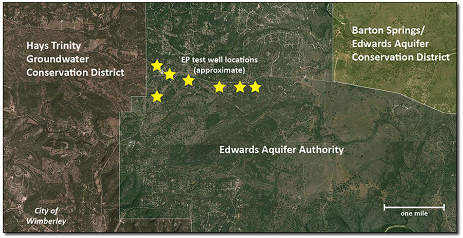
This area in question here was within the jurisdiction of the Edwards Aquifer Authority, but that agency only asserts control over the one layer of limestone that is the Edwards, not the underlying layer that is the Trinity.
|
Just to the east of the site is the Barton Springs Edwards Aquifer Conservation District, but that agency also does not assert or claim jurisdiction over wells in the Trinity.
Just to the west and north of the site is the Hays-Trinity Groundwater Conservation District, and whether or not the site is in their jurisdiction appears to be another subject of a court battle we will examine shortly. The agency's own map of their jurisdictional area appears to show it is not under their control (see their map). A GIS analysis by Robin H. Gary of the Barton Springs district estimated there are 1,589 groundwater-supplied properties within two miles of the Electro Purification test wells (see the analysis). Meanwhile, nobody really believes any of these various limestone formations are completely separate and unconnected. In recent years we have learned a lot about interconnections between the Edwards and the Trinity, and about connections between the San Antonio and Barton Springs segments of the Edwards. Yet the regulatory structure in Texas accounts for none of this. In recognition of these interconnections, the Barton Springs Edwards Aquifer Conservation District expressed concerns that overpumping the Trinity could affect parts of the Edwards within its jurisdiction and in mid-January of 2015 it asked the Buda City Council to delay consideration of the city's proposed contract with Electro Purification. (40) Buda did not delay, however. On January 20, the Buda City Council heard from a parade of concerned citizens and officials, added provisions that require mitigation of impacts on local wells, and then voted 6-1 to sign a contract with Electro Purification. Three days later more than 200 people packed the Wimberley Community Center for a meeting of the Hays-Trinity Groundwater Conservation District, hoping to hear of strategies to regulate or stop the project. What they heard was not encouraging. The District could try to annex the portion of the Trinity where the Electro Purification wellfield is proposed, but it would be difficult and may require legislative action, and even if successful the District is simply broke. It has no taxing authority or even the ability to charge groundwater production fees. (41) By mid-February, tensions in the area were rising even further. Buda Mayor Todd Ruge told an Austin news station he had been receiving threats, and Wimberley residents organized a "Boycott Buda" campaign, pitting neighbor against neighbor. "Save Our Wells" bumper stickers began appearing on cars all over Wimberley. (42), (43) On February 25, the Wimberley Valley Watershed Association announced the formation of a new non-profit group, the Trinity Edwards Springs Protection Association, or TESPA. A press release said it was formed as a response to the Electro Purification proposal, but that it intended to address issues that go beyond the pumping dispute to include more general protection for springs throughout central Texas. One of the founders of the group was noted environmental attorney Jim Blackburn. The press release also said the group intended to file suit. (44) See press release. Within weeks, TESPA had filed a petition in Hays county asking a court to issue a temporary injunction stopping any drilling or pumping and maintaining the status quo until the larger issues could be decided, which could easily take years. One of the arguments made is the area is within the jurisdiction of the Hays-Trinity Groundwater Conservation District by default, because no other agency is regulating the Trinity in Hays county and "The Legislature evidenced an intent that all groundwater in Hays County be protected by a groundwater conservation district." The petition asserts the defendants have failed to comply with the mandatory permit requirements required by the Texas legislature through the District, and it asked the court to halt all activity until permits are obtained. See original petition. The petition also asked that if injunctive relief cannot be provided under the section of the Texas Water Code that provides for Groundwater Conservation Districts, the court provide that relief by applying a doctrine of "reasonable use", also known as "the American rule". This doctrine is generally thought to be almost the opposite of the English common law "rule of capture" that prevails where no Groundwater Conservation District has jurisdiction, but the petition points out that even in the 1904 court case that established the rule of capture, the decision hinged on the defendant making a "reasonable and legitimate use" of the water it took from under its land. "Thus, the foundation upon which the rule of capture rests in Texas, actually is a foundation which already recognizes reasonable use." The petition also points out that since 1904, the rule of capture in Texas has been modified or limited many times, and the entire paradigm of regulating using Groundwater Conservation Districts employs a "reasonable use" doctrine. For these reasons, the petition asserts the rule of capture "is a tattered remnant of the original rule causing more harm than good." The petition urges the court to recognize "the rule of capture is no longer defensible, and in fact is dangerous public policy as it risks exhaustion of critical water resources." Meanwhile, on the legislative front, State Representative Jason Isaac of Dripping Springs and State Senator Donna Campbell filed a flurry of bills aimed at stopping the Electro Purification project. One bill was to expand the territory of the Barton Springs/Edwards Aquifer Conservation District to include the wellfield and a second bill would do the same for the Hays Trinity Groundwater Conservation District. Lawmakers recognize that only one bill can pass because an area can only be in one district but they elected to apply a "shotgun" approach. A third bill would limit the eminent domain powers of the Goforth Special Utility District, making it probably unable to build a pipeline. (45) When the bills were heard by the House Natural Resources Committee on March 24, they ran into harsh criticism from other lawmakers. Committee vice-chairman Trent Ashby of Lufkin said Electro Purification is "not violating any laws here. They're playing by the rules." The most controversial bill was the one that would strip the Goforth District of its eminent domain powers, but it was the Legislature itself that gave it those powers and the lawmakers said they were reluctant to set a precedent of taking away powers they had given. (46) All three bills were left pending in committee (47), which usually means they advance no further, but supporters campaigned hard using social media and email alerts asking people to contact legislators directly. In May of 2015, a decision by the Texas Supreme Court to let stand a lower court ruling was interpreted by legal experts as extremely favorable to the position of Electro Purification. (47) In that case, the lower court ruled that a taking occurred when the Edwards Aquifer Authority limited the ability of pecan farmers Glenn and JoLynn Bragg to pump water from under their land. Read about that case on the Laws and Regulations page. In June of 2015, the efforts of the Save Our Wells crowd paid off when House Bill 3405 became law without the Governor's signature. The contested area was added to the Barton Springs-Edwards Aquifer |
Conservation District, and persons who had planned projects will get a chance to demonstrate their pumping will not cause a failure to achieve Desired Future Conditions or cause unreasonable impacts on existing
wells. The law requires that persons operating a well or who have entered into a contract must file a permit application and will be given a temporary permit for an amount up to the production capacity of the well. A regular permit will then be processed and the authorized amount could be reduced if the applicant can't prove that Desired Future Conditions will be met and there will be no unreasonable impact on existing wells. Get HB 3405 here. In September of 2015 the Texas Tribune noted that HB 3405 might not actually thwart pumping plans by Electro Purification, because an "unreasonable impact" is a subjective standard and nobody really knows what it means. Conservation District General Manager John Dupnik said "What does 'unreasonable impact' mean? We don't know. We've got to work through it. Any time you see the term 'unreasonable', that's where the attorneys really get excited, right?" Even so, residents and local officials who succeeded in getting HB 3405 passed remained confident the science would demonstrate an unreasonable impact and EP would ultimately get less water than it asks for. (50) In October of 2015, EP asked for almost nothing - it applied for a permit to pump 100 acre-feet annually from the Trinity, or about 89,000 gallons per day, which is a small fraction of the 5.3 million gallons per day envisioned. (51) It was not clear if EP had abandoned its plans or if this was part of a legal strategy. In March of 2016, the Barton Springs-Edwards Aquifer Conservation District began a formal rulemaking process as part of their new responsibility to manage the area that legislators added to their district with the 2015 legislation. The District noted that proposed rules would focus on management strategies that will protect existing wells and preserve the long-term availability of water supplies from the Trinity Aquifer. Under the proposed rules, applications for large-scale groundwater projects would require more rigorous aquifer testing, an expanded public outreach area, and continued aquifer monitoring. "These rule changes would establish a framework to allow for a science-based evaluation of prospective applications, assess the potential for unreasonable impacts to existing wells and the aquifer, and require the necessary measures to avoid those impacts," said District General Manager John Dupnik. (52) By June of 2016 the District had processed about 20 applications for existing wells that were required to obtain a permit, and it had issued Regular Production Permits to all but one. Low capacity wells that produce from the Trinity Aquifer and are used only for domestic purposes are exempt from having to obtain a permit. Mr. Dupnik said his District was actively working on building relationships with residents in the newly regulated territory. He said a lot of effort had been put into organizing outreach sessions to give residents access to the District and to inform them on what BSEACD does. (53) On May 27, 2016 the Texas Supreme Court issued a ruling that may have implications for TESPA and efforts to limit pumping from the Trinity. The Court ruled that Texas' "accommodation doctrine" should also apply to groundwater, in addition to oil and gas. Under this doctrine, owners of underground mineral rights such as oil and gas must accommodate the activities of whoever owns the surface estate. This means, for example, that surface landowners now have a specific legal doctrine on which to challenge plans to pumpwater from below their property. And so some observers hailed the decision as a major victory for landowners. Others were not so positive, because the ruling also establishes the rights of groundwater owners are dominant over those of surface owners. The groundwater owners now have an explicit and expansive right to access the surface tract without the permission of the surface owner and without compensation. Also, the burden of proof under the accommodation doctrine is very high and falls on the surface landowner. In the Texas Tribune, Austin water lawyer Vanessa Puig-Williams noted that landowners must not only prove that drilling operations will substantially impair their existing use of the land and that there are no reasonable alternatives, but they must also prove that reasonable alternatives are available to the producer. Historically, it has been difficult to meet that burden in oil and gas drilling disputes. "The accommodation doctrine is really not that protective of the surface owner's interests," she said. (54) In July of 2017, Electro Purification submitted a scaled-back application to pump up to 2.5 million gallons per day, down from the original 5.3 million. In October of 2017 another company's plans to increase its pumping from the Trinity raised concerns among nearby residents. Texas Water Supply Company, which already sells water to San Antonio Water System, partnered with a New York private equity firm Brightstar Capital Partners to expand sales to others. Brightstar senior partner Raul Deju said "We have a lot of existing wells and we have a lot of capacity." A news release stated that wells controlled by Texas Water Supply Company could produce up to 32,000 acre-feet per year. Deju said the company could ramp up to that level of production "within the next eight years." Officials with the Trinity Glen Rose District expressed concerns about the proposal in a letter. It said "The proposed withdrawal now makes it much more difficult, if not almost impossible, to manage this resource effectively. We realize this has an impact not just to our district, but has the potential to impact all within the area." Deju said "We operate by the book. I'm an environmentalist at heart. We're going to operate these wells appropriately, adequately and in accordance with all laws and regulations." Meanwhile, SAWS officials said they have found the water from the company to be unreliable. SAWS President and CEO Robert Puente said "Buyer, beware, because that Trinity is very unpredictable. Well, actually, it is predictable. In a drought, you can't rely on it." (55) In May of 2018, Electro Purification was back in the news when the BSEACD announced a 20-day comment period on the company's application. About 100 residents gathered at Blue Hole Regional Park in Wimberley to protest the application. The BSEACD general manager and staff recommended a five-year, multi-phase ramping up of production and monitoring of any potential negative impacts on the Aquifer. In Phase I the company would pump 273,750,000 gallons per day, in Phase II 1.0 million gallons per day, Phase III 1.5 million gallons per day, and Phase IV 2.5 million gallons per day. General Manager Kirk Holland said "The board would ultimately be hard pressed to say, 'you can't produce groundwater under your property, or leased property.' We need to look at what provisions could allow for pumping in a way that protects the resources of other people that have private property rights in the area." (56,57,58) By June of 2018, opponents had sprung back into action and filled the Wimberley Community Center for an informational session on the details of the proposed water production permit. Resident Tom Sosebee said "We thought it was behind us, that EP wasn't going to happen. Here we go again." (59) At their July 10, 2018 meeting, Hays County Commissioners unanimously supported a resolution to support contesting the proposed permit. (60) |
CHANGING VIEWS OF THE TRINITY
|
In 1953, the Trinity Aquifer was deemed unsuitable for large development. Researchers from the United States Geological Survey found the water in all the wells they investigated was brackish and light flowing, and their laboratory analysis of the water quality found it was unsuitable for public supply. Fifty years later, even extremely low-yielding members of the Trinity group, such as the Upper Glen Rose
|
formation, are seen as playing a big role in meeting the future demands of fast-growing counties. Other small Hill Country aquifers mentioned in 2013 as contributing to future supplies were the Ellenberger, Hickory, and Marble Falls aquifers. All of them have been deemed "non-relevant" for regional planning purposes, but some now want them included in future supply inventories.
|
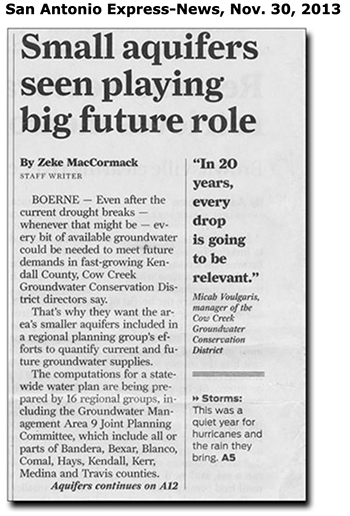
|
|
Materials used to prepare this section:
Texas Water Development Reports 195, 235, 269, 273, 345, 353, and 373 are available online at the TWDB's Groundwater Reports Page.
Anaya, Roberto and Ian Jones, (2009). Groundwater Availability Model for the Edwards-Trinity (Plateau) and Pecos Valley Aquifers of Texas. Austin: Texas Water Development Report No. 373, April 2009.
Ashworth, John B and Hopkins, Janie. Major and Minor Aquifers of Texas. Austin: Texas Water Development Report No. 345, November 1995.
Ashworth, John B. Ground-Water Availability of the Lower Cretaceous Formations in the Hill Country of South-Central Texas. Austin: Texas Water Development Report No. 273, January 1983.
Beach, James and Kristie Laughlin, (2015). Hydrogeologic Evaluation of Proposed Electro Purification, LLC Project in Hays County, Texas. Austin: prepared for Braun and Gresham, Attorneys At Law, March 2015.
Klemt, William B., Perkins, Robert D., and Alvarez, Henry J. Ground-Water Resources of Part of Central Texas with Emphasis on the Antlers and Travis Peak Formations, Vol.1. Austin: Texas Water Development Report No. 195, November 1975.
Kuniansky, Eve L., and Holligan, Kelly Q. (1994). Simulations of Flow in the Edwards-Trinity Aquifer System and Contiguous Hydraulically Connected Units, West-Central Texas. Austin: US Geological Survey, Water-Resources Investigations Report 93-4039.
Mace, Robert E., Ali H. Chowdry, Roberto Anaya, and Shao-Chih (Ted) Way. Groundwater Availability of the Trinity Aquifer, Hill Country Area, Texas: Numerical Simulations through 2050. Texas Water Development Board Report No. 353, September 2000.
Nordstrom, Philip L. Occurrence, Availability and Chemical Quality of Ground Water in the Cretaceous Aquifers of North-Central
Texas, Volume 1. Austin: Texas Water Development Report No. 269, April 1982.
Walker, Lloyd E. Occurrence, Availability and Chemical Quality of Ground Water in the Edwards Plateau Region of Texas. Austin: Texas Water Development Report No. 235, July 1979.
(1) "SAWS adding 2 supply sources" San Antonio Express-News, February 16, 2000.
(2) "Water study paints bleak picture for Trinity aquifer." Hill Country Recorder, March 22, 2000.
(3) "TNRCC seeks input about Trinity Aquifer" San Antonio Express-News, July 24, 2000.
(4) "SAWS plans to tap Trinity Aquifer" San Antonio Express-News, September 20, 2000.
(5) "Trinity Aquifer rules sought" San Antonio Express-News, September 20, 2000.
(6) "Trinity Aquifer measure approved" San Antonio Express-News, April 6, 2001.
(7) "Golf course group vows neighborly water use" San Antonio Express-News, April 19, 2001.
(8) "Pumping is limited from Trinity Aquifer" San Antonio Express-News, April 26, 2001.
(9) "Bulverde residents fear golf course" San Antonio Express-News, April 26, 2001.
(10) "PGA project won't be the water saver it's cracked up to be" San Antonio Express-News, April 26, 2001.
(11) "Trinity district trips golf course" San Antonio Express-News, April 27, 2001.
(12) "Kerr vote seen as favoring water rule" San Antonio Express-News, May 10, 2001.
(13) "House approves tax district for golf resort" San Antonio Express-News, May 16, 2001.
(14) "Taxing district ok'd for Bexar resort" San Antonio Express-News, May 24, 2001.
(15) "Water alliance seeks regional focus" San Antonio Express-News, July 18, 2001.
(16) "Chemical weapons dump is posing aquifer threat" San Antonio Express-News, July 1, 2001.
(17) "Threat to aquifer overstated" San Antonio Express-News, July 3, 2001.
(18) "Wells near Army post are tainted" San Antonio Express-News, August 26, 2001.
(19) "New wells could drain water store" San Antonio Express-News, October 21, 2001.
(20) "Trinity water district asks Bexar for $78,000" San Antonio Express-News, November 2, 2001.
(21) "Water District defeat decried" San Antonio Express-News, November 9, 2001.
(22) "Denial of well permit for ranch is drawing heat" San Antonio Express-News, November 16, 2001.
(23) "City hits water bonanza" San Antonio Express-News, December 12, 2001.
(24) "Bullis chemical not in wells" San Antonio Express-News, June 22, 2002.
(25) "Trinity Aquifer's future on ballot" San Antonio Express-News, October 23, 2002.
(26) "New water agency gets heavy support" San Antonio Express-News, November 6, 2002.
(27) "San Marcos picks neophytes; Trinity water district approved" San Antonio Express-News, May 4, 2003.
(28) "New water district sets fees for pumping Trinity Aquifer" San Antonio Express-News, May 23, 2003.
(29) "Western Comal vulnerable to water hogs" San Antonio Express-News, June 17, 2003.
(30) "Kendall groundwater group pushing on" San Antonio Express-News, August 23, 2003.
(31) "Golf resort in fight over water use " San Antonio Express-News, June 26, 2008.
(32) "Golf resort's use of water attracts fine, perhaps state probe" San Antonio Express-News, July 16, 2008.
(33) "Still spring troubles Hill Country" San Antonio Express-News, November 1, 2008.
(34) "Water discussions reach boiling point" San Antonio Express-News, March 19, 2009.
(35) "Trinity Aquifer’s supply to be curbed" San Antonio Express-News, July 27, 2010.
(36) "State pressure revives talk of water district" San Antonio Express-News, March 10, 2012.
(37) "TCEQ wants to resume Comal GCD hearings" New Braunfels Herald-Zeitung, July 3, 2013.
(38) "Comal county again to press for water district" San Antonio Express-News, December 4, 2014.
(39) "Firm’s plan to pump, sell water raises alarm in northern Hays County" Business Week, January 22, 2015.
(40) "Buda City Council OKs controversial water contract" Community Impact Newspaper, January 23, 2015.
(41) "Groundwater wars brewing in Austin’s suburbs" Texas Tribune, January 23, 2015.
(42) "Buda’s mayor alleges threats over water deal" KVUE Austin News, February 20, 2015.
(43) "Hays County towns feuding over well field" Austin American-Statesman, February 26, 2015.
(44) Wimberley Valley Watershed Association press release, February 25, 2015.
(45) "Bills filed to stop controversial Hays well project" Austin American-Statesman, March 13, 2015.
(46) "Hays County water fight tumbles into committee" Texas Tribune, March 25, 2015.
(47) "State Supreme Court punts on major water case" Texas Tribune, May 4, 2015.
(48) "GCD for Trinity OK'd in Austin" New Braunfels Herald-Zeitung, June 24, 2015.
(49) "Comal groundwater district is surfacing" San Antonio Express-News, July 30, 2015.
(50) "New law may not thwart Hays county water project" Texas Tribune, September 9, 2015.
(51) "Electro Purification seeks permit to pump far less than feared from Trinity Aquifer" San Marcos Mercury, October 13, 2015.
(52) "Rule changes proposed to better manage Trinity Aquifer" San Marcos Daily Record, March 7, 2016.
(53) "HB 3405: So far, so good" News-Dispatch, June 17, 2016.
(54) "Lawyers Say Ruling Bad For Landowners, Good For Water Marketers" Texas Tribune, June 7, 2016.
(55) "Trinity Aquifer plan is being eyed warily" San Antonio Express-News, October 27, 2017.
(56) "Kyle: Electro Purification is back" Hay Free Press, May 10, 2018.
(57) "Wimberley residents protest 2.5M gallon/day pump permit" Hay Free Press, May 24, 2018.
(58) "Aquifer district to phase in EP pumping" Hay Free Press, May 31, 2018.
(59) "Hays County residents fear the fight to protect their water was all for nothing" Texas Tribune, June 29, 2018.
(60) "Hays County leaders support contested case for water permit" Hay Free Press, July 12, 2018.


Texas Water Law
|
In Texas, water rights depend on whether the water is groundwater or surface water.
Generally, Texas groundwater belongs to the landowner. Groundwater is governed by the rule of capture, which grants landowners the right to capture the water beneath their property. The landowners do not own the water but have a right only to pump and capture whatever water is available, regardless of the effects of that pumping on neighboring wells. Surface water, on the other hand, belongs to the state of Texas. It can be used by a landowner only with the state's permission. GROUNDWATER Water found below the earth's surface in the crevices of soil and rocks is called percolating water, or more commonly groundwater. Texas groundwater law is judge-made law, derived from the English common law rule of "absolute ownership." Groundwater belongs to the owners of the land above it and may be used or sold as private property. Texas courts have adopted, and the legislature has not modified, the common law rule that a landowner has a right to take for use or sale all the water that he can capture from below his land. Because of the seemingly absolute nature of this right, Texas water law has often been called the "law of the biggest pump." Texas courts have consistently ruled that a landowner has a right to pump all the water that he can from beneath his land regardless of the effect on wells of adjacent owners. The legal presumption in Texas is that all sources of groundwater are percolating waters as opposed to subterranean rivers. Consequently, the landowner is presumed to own underground water until it is conclusively shown that the the source of supply is a subterranean river. The state of the law with respect to ownership of subterranean rivers is not settled in Texas. Both stream underflow and subterranean rivers have been expressly excluded from the definition of underground water in Section 52.001 of the Texas Water Code. The practical effect of Texas groundwater law is that one landowner can dry up an adjoining landowner's well and the landowner with the dry well is without a legal remedy. Texas courts have refused to adopt the American rule of "reasonable use" with respect to groundwater. Exceptions to Absolute Owner Rule There are five situations in which a Texas landowner can take legal action for interference with his groundwater rights: * If an adjoining neighbor trespasses on the land to remove water either by drilling a well directly on the landowner's property or by drilling a "slant" well on adjoining property so that it crosses the subterranean property line, the injured landowner can sue for trespass. * There is malicious or wanton conduct in pumping water for the sole purpose of injuring an adjoining landowner. * Landowners waste artesian well water by allowing it to run off their land or to percolate back into the water table. * There is contamination of water in a landowner's well. No one is allowed to unlawfully pollute groundwater. * Land subsidence and surface injury result from negligent overpumping from adjoining lands. Limited Regulation of Groundwater The Texas Legislature acknowledged private ownership of percolating groundwater in legislation passed in 1949 and again in 1985, when it authorized the establishment of underground water conservation districts. These districts generally have the authority to promulgate rules for conserving, protecting, recharging, and preventing waste of underground water. SURFACE WATER Texas water law has evolved from conflicts between competing legal systems and from the necessity of developing a system that fits the needs of Texas. Water law will continue to evolve as the conditions of society, politics, populations, and economics changes. Two legal doctrines of surface water law are recognized in Texas today-the riparian doctrine and the prior appropriation doctrine. Riparian Doctrine The riparian doctrine is based on English common law. These court-developed rules are used in deciding cases that involve water use conflicts. The basic concept is that private water rights are tied to the ownership of land bordering a natural river or stream. Thus, water rights are controlled by land ownership. Riparian landowners have a right to use the water, provided that the use is reasonable in relation to the needs of all other riparian owners. Riparian owners retain the right to use water so long as they own the land adjacent to the water. Prior Appropriation Doctrine This doctrine, on the other hand, is controlled by statute. Applied in the western states, prior appropriation is not related to land ownership; instead water rights are acquired by compliance with statutory requirements. While the principles of riparian rights were appropriate in areas of England and the United States where rainfall averages 30 inches or more a year, these rights were not suited to the arid West. During their early development, western states failed to control rivers and streams, and water was treated as though it belonged to no one. In |
the absence of any rules, people simply took water from streams and used it; that is, they appropriated it. When this practice became legalized, it became known as the Doctrine of Prior Appropriation.
In 1967 the Texas Legislature merged the riparian rights system into the prior appropriation system with passage of the Water Rights Adjudication Act. The act required any person claiming a riparian water right to file a claim for the right by 1969 with the Texas Water Commission. With passage of the 1967 act, Texas consolidated the allocation of surface water into a unified water permit system. Anyone wishing to use surface water (exclusive of drainage water) must receive permission from the state in the form of a "water right." Awarding permits for these "water rights" is a task of the Texas Commission on Environmental Quality. Drainage WaterDiffused surface water, in its natural state, occurs after rainfall or snowmelt and flows across land from high elevations to lower elevations. This diffused water is often called stormwater, drainage water or surface runoff. Once the water flows into a clearly defined watercourse, it is claimed by the state and is subject to appropriation. On its way to the watercourse, drainage water often flows across privately owned lands. In such cases the water does not automatically become the property of the landowners, although they may capture and use it. Legal problems arise when a landowner interferes with the natural flow of drainage water by capturing and holding the flow or by diverting or increasing it. There are three general rules of law that apply when diffused surface water is captured or diverted. Common Enemy Rule One is called the "common enemy rule." Under this rule, drainage water is regarded as an enemy common to all landowners. The law allows every owner to take any measure to protect property, regardless of the consequences to other neighbors. Natural Flow or Civil Law Rule This rule recognizes that each landowner is entitled to rely upon continuation of the natural flow. Under this rule a landowner who increases runoff, thereby causing flooding, is liable for damages. Reasonable Flow This rule allows landowners to divert or change drainage water, even to the extent of harming adjoining neighbors, so land as the diverter's actions are "reasonable" considering all circumstances WHAT RIGHTS DO LANDOWNERS HAVE TO USE GROUNDWATER? From an ownership perspective, Texas groundwater law is simple and straightforward: Groundwater is the private property of the owner of the overlying land. The owners of the land have the right to capture the groundwater beneath their land. However, the adjoining landowners have the same right to pump water from beneath their properties. Pumping water sometimes causes the groundwater beneath one property to move to an adjoining property and cause the nearby landowner's wells to go dry. The rule of capture was adopted by the Texas Supreme Court in 1904 in Houston & T.C. Ry. Co. v East, 81 S.W. 279 (Texas 1904). This rule allows landowners to pump as much water as they chose, without liability to surrounding landowners who might claim that the pumping has depleted their wells. The rule of capture has been followed by the courts ever since that 1904 decision. Texas groundwater law has often been called the "law of the biggest pump." This means that the deepest pump gets the water and the shallower well goes dry. WHAT IS THE LATEST WORD FROM THE SUPREME COURT ON THE RULE OF CAPTURE? Some 95 years after the East decision, the Texas Supreme court reviewed the rule in Sipriano v. Great Spring Waters of America, et al., 1 SW3d 75 (Texas 1999) [Ozarka]. The Ozarka case involved a claim by a domestic well owner that Ozarka's nearby pumping had dried up his well. The landowner asked the court to protect his private-property interest in groundwater by imposing liability on Ozarka. Many observers thought that the Texas Supreme court would modify the capture rule to protect rural homeowners and domestic users of water. They were wrong. The court unanimously affirmed the rule of capture. However, it suggested that it might change the rule in the future if the Texas Legislature did not adequately address groundwater overpumping. The Legislature's response was to strengthen the laws enabling citizens to manage this problem locally through groundwater conservation districts. Publications Handbook of Texas Water Law, Ronald A. Kaiser Questions about Groundwater Conservation Districts in Texas, Ronald A. Kaiser. Bruce J. Lesikar, Valeen Silvy Who Owns the Water?, Ronald A. Kaiser Reproduced with permission from the July 2005 issue of Texas Parks & Wildlife magazine. Links |
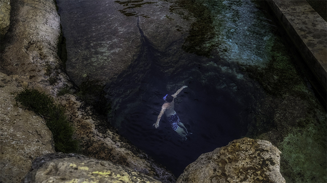
Diving from the limestone cliff into the deep blue depths of Jacob’s Well in Hays County is a rite of passage for Hill Country teens. Photo © Brian Lehmann / Circle of Blue
When It Rains, Texas Forgets Drought and Worsening Water Scarcity
After The Pandemic, Soaring Population Growth, Development Will Again Challenge Planning and Water Supply
By Keith Schneider
August 3, 2020
August 3, 2020
|
WIMBERLEY, Texas – Among the famed springs that distinguish the Texas Hill Country as a region of crystal-clear water and iconic swimming holes, Jacob’s Well stands out. The spring’s water source is rain that falls on the thin soils of Hays County and filters through porous limestone before filling a network of deep, ancient caves.
The water rises back to the surface from a hole, about 12 feet across, in the bottom of Cypress Creek. The round opening is so blue, so shimmering, that viewed from the top of a nearby limestone cliff it looks like an eye. Unblinking as it emerges from the darkness, the water forms an intent gaze that appears capable of seeing the opposing moods of the Hill Country: the calming influence of ample water supply in wet seasons, and surging alarm during drought. When it’s wet in Hays County and the 16 other counties that form the Hill Country. Jacob’s Well pours about 900 gallons a minute into Cypress Creek, more than enough to fill the Blue Pool downstream that is a summertime recreational asset in this town of 3,000 residents. In wet years, ample rainfall means that the various circumstances of economic development — population growth, land use changes, water supply — are like soft breezes, licks of wind that are not terribly distracting. But in dry years, water typically heads that list of priorities, in all caps. Months of rainless weather produces a fury of cultural anxiety about water scarcity. Those breezes gather force into much stronger gales of public discord and blame. Dry years reveal a momentous confrontation as residents encounter the menacing consequence of runaway growth. Stated most succinctly, the Hill Country could run out of water unless it substantially alters its pattern of booming population growth, industrial development, and housing construction now occurring in the region — and for that matter, across much of the rest of the state. “Texas does not understand shortages,” said Dr. Larry McKinney, director of the Harte Research Institute for Gulf of Mexico Studies, a unit of Texas A&M University in Corpus Christi. “It’s the Texas mentality. Texas is so big we’ve had a hard time coming to grips that resources are finite. We really never had to deal with that. Frankly, we’re reaching that point. “The Hill Country is the prime example,” McKinney went on to say. “Growth there has just gone crazy. People don’t grasp that there are limits and we are approaching those limits. And the time to make change is now, before the costs are just too huge to consider.” STATE WATER PLANNING PUMMELED BY DROUGHTS In many ways the story of Texas over the last century is the state’s devout allegiance to the principle that mankind has dominion over nature. The pandemic shut down that idea in 2020. Fast rising Covid-19 case numbers and deaths made public health and safety the primary concern. Hays County counted almost 4,300 confirmed infections and 28 deaths as July ended. The climate disruption occurring in Texas, along with booming population and economic growth, also is writing a much different story of vulnerability — to nature’s bullying and to government’s uncertain capacity to adjust. This article is the first of a five-part series on the consequences of the mismatch between runaway development and tightening constraints on the supply and quality of fresh water in Texas. Along with this report, the Water, Texas project provides close examinations of other crucial aspects of the state’s resource challenges: energy development risks to the Big Bend region, water innovations in three major Texas cities, how the new border wall intrudes on the ever present civic conversation about water supply and growth in the Lower Rio Grande Valley, and the influence of water and drought on the Texas economy. Water, Texas is funded by the Cynthia & George Mitchell Foundation. Its intent is to inform citizens and policymakers, and help influence investments and new practices to assure a drying Texas has adequate supplies of clean fresh water. It’s not that Texas has ignored the desperation that accompanies drought. A terrible long drought in the early 1950s spurred the Legislature to establish the Texas Water Development Board to essentially do what it can to relieve the stress of deep droughts. The agency serves as instigator, funder, researcher, collaborator, idea center, and data gatherer for all the cities and towns, universities, groundwater conservation districts, permitting agencies, and conservation groups involved in securing sufficient water. The Water Development Board’s State Water Plan, issued every five years, is regarded as the chief playbook for determining what needs to be done over the next 50 years. It offers direction on how much must be spent in Texas to safeguard its freshwater reserves; it also encourages conservation and new practices that will make it easier to live through droughts. Hydrologists crunch numbers about water demand and use. Engineers dream up expensive fixes for supplying reservoirs and extensive pipelines for tapping distant reserves. And still, the barriers for getting it right — for the state’s response to the next drought to be adequate to cope with the peril — are high. The primary reason is that there are more years in Texas with adequate rain than dry ones. In those wetter years another state value takes precedence: economic growth. At the core of the Texas economy are three thirsty economic sectors: agriculture, fossil fuel production and processing, and real estate development. That’s why the episodic absence of rain over long periods blows big holes in the success of the state’s water planning. In 2011, the driest year ever recorded in Texas, water scarcity caused a near panic in the Hill Country and across the state. Wells dried up. Reservoirs emptied. There wasn’t enough river water to cool power plants. Bays and estuaries normally refreshed by the great Texas rivers that bring fresh water to coastal waters grew saltier, causing severe damage to fisheries. Water, of course, is the lifeblood of all human activity. But the mismatch between population and industrial growth and securing the state water supply is so disproportionate in wet years that the next deep drought in a much bigger, more populous, and thirstier Texas is likely to be far more dangerous. “There just won’t be enough water for all,” said Margo Denke, an endocrinologist and founder of Friends of Hondo Canyon, a citizen group battling a developer to prevent damage to a Hill Country stream. “There won’t be mechanisms in place to distribute and use wisely the water that is available.” 
Two generations ago about 40,000 people made their homes in Hays County, an epic, rural, rolling masterpiece of space and sky. Authorities in Hays counted 14,000 homes. Forty years later Hays County has grown to 222,000 residents and 75,000 housing units. Photo © J Carl Ganter/CircleofBlue.org
RISING DEMAND CONFRONTS LOWER SUPPLIES
There are a couple of ways to examine the coming hardship. The first is in numbers. The Water Development Board and every other responsible research group has found two signal trend lines are colliding – demand and supply. By 2070, largely due to Texas’s strong economy and attractive big cities, the state will grow to 51 million, 22 million more people than today. The state’s demand for water, the State Water Board projects, will climb to 21.6 million acre-feet, up from 18.4 million. (One acre-foot is roughly 326,000 gallons.) Projected water demand in Hays County, Texas, from 2020 through 2070. Data provided by the Texas Water Development Board in acre-feet. 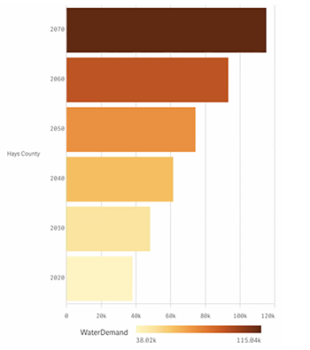
Since 2003, a pipeline from Lake Travis, a reservoir near Austin, has provided developers sufficient water to continue building big subdivisions in the Hill Country. Photo © J. Carl Ganter /CircleofBlue.org
At the same time, a severe drought will bring increasing constraint. State authorities project that in a drought comparable to the most severe on record water available in aquifers, as well as supplies from rivers and other surface water sources, will fall over the next 50 years from 15.2 million acre-feet to 13.6 million acre-feet. During the driest periods, more people will have less water. Considerably less water.
Here’s how that confrontation is playing out in the Hill Country, the epicenter of population growth and uncertain water supply in Texas. Two generations ago about 40,000 people made their homes in Hays County, an epic, rural, rolling masterpiece of space and sky close to Austin and San Antonio. Authorities in Hays counted 14,000 homes supplied with water from the Trinity Aquifer, a giant freshwater reserve that lay below. In wet years and in dry ones, water was readily available. The clear waters of Jacob’s Well bubbled up so steadily that diving from that limestone cliff into the deep blue eye was a rite of passage for Hill Country teens. Forty years later Hays County has grown to 222,000 residents and 75,000 housing units. The Trinity Aquifer is tapped out. Since 2003, a pipeline from Lake Travis, a reservoir near Austin, has provided developers sufficient water to continue building big subdivisions. But a study by the Hill Country Alliance and the Meadows Center for Water and the Environment at Texas State University in San Marcos found that the piped water encouraged more water well drilling into the aquifer. In one area, they found that pumping jumped from just over 3 million gallons annually to 90 million gallons. On Jacob’s Well, the effect of pumping a depleted aquifer was immediately apparent. Starting in 2000, there were days it stopped flowing. David Baker, an artist and water advocate, is principal caretaker of Jacob’s Well. Born 61 years ago in Lawrence, Kansas, and raised in Kansas City, Baker first laid eyes on Jacob’s Well in 1988 when he rented a house on the well owner’s 25-acre ranch. He bought the spread in 1990. Over the next 30 years he became an expert in Hill Country hydrology, founded and directed the non-profit Wimberley Valley Watershed Association, convinced the county to establish a park around Jacob’s Well, and assembled 300 acres of undeveloped land as a recharge conservation zone to ensure the spring’s steady flow. It’s painstaking work. Work, says Baker, that needs to be replicated across the Hill Country. “We’re building all this stuff, subdivisions, shopping centers on top. We’re trashing the surface. We’re draining the aquifer,” Baker said. “We don’t have sufficient water supply to keep doing that.” 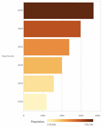
Projected population in Hays County, Texas, from 2020 through 2070. Data provided by the Texas Water Development Board, in acre-feet.
This year, ample rainfall in the winter produced dividends for Baker and the groups of people from in and outside Texas that visit Jacob’s Well every day. The spring generated a steady flow into Cypress Creek, and from there into the Blanco River, which feeds the San Marcos River, which feeds the Guadalupe River, which provides much of the freshwater that reaches the San Antonio Bay estuary along the Gulf of Mexico.
Baker ticked off the watery track from the spring to the Gulf. “What happens here also affects whatever happens downstream,” he said. “Most people around here don’t connect the dots. They just don’t see the effects.” 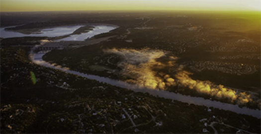
Since 2003, a pipeline from Lake Travis, a reservoir near Austin, has provided developers sufficient water to continue building big subdivisions in the Hill Country. Photo © J. Carl Ganter /CircleofBlue.org
DOWNSTREAM TURMOIL
That may be true in Hays County. It’s not true downstream in the state’s Gulf Coast estuaries. Because less water drains from the Hill Country, some Gulf Coast estuaries — nursing grounds for sport fisheries, shrimp and oysters, and grassy resting and breeding grounds for migratory birds and water fowl — are shrinking. Texas wildlife and fisheries managers have been aware of this condition of water scarcity since the state’s population began increasing by 250,000 annually in the 1980s. That rate of growth is almost double now. One of the epicenters is the Hill Country, where Austin and San Antonio are among the fastest growing cities in the nation. The population of Hill Country counties — 1.6 million in 1980 — now exceeds 4 million. And it got there a full decade earlier than demographers projected. Larry McKinney of the Harte Research Institute has watched the upstream growth up close. He owns a home in Hays County that was surrounded by vistas and fields and is now hemmed in by 5,000-home subdivisions to the east and west. Dr. McKinney is also among the foremost experts in the life cycles of Gulf Coast estuaries, especially Corpus Christi Bay. Before assuming leadership of the Harte Institute 14 years ago, he spent a good chunk of his career at the Texas Parks and Wildlife Department, where he led work to determine how much fresh water was needed to keep the state’s important bays and estuaries healthy. By 1994 his team had the numbers. Corpus Christi Bay, for instance, required 1.15 million acre-feet of fresh water to sustain healthy shorelines, shrimp and oyster nurseries, and an active sport fishery. Drainage from the western Hill Country into the Nueces River provided most of that water which, in the parlance of water regulators and hydrologists, is called “environmental flow.” Keeping the bay healthy meant requiring upstream water users to conserve enough water to secure environmental flows to the Gulf. It required both hydrology and politics to achieve that goal. Upstream users were not inclined to use less water unless it was required — and Texans are notorious for disdaining rules and strictures. The 57-year-old Texas Parks and Wildlife Department, though, is an agency with sufficient political muscle. The department oversees 10 major bays and estuaries, wildlife habitat and refuges, parks, sport fishing, commercial shrimping, and oyster harvesting along the state’s 367-mile Gulf Coast. Taken together, the agency’s oversight is closely tied to at least $5 billion in annual tourist and recreational income. The condition of the coast and the lifestyle it encourages accounts for billions of dollars more in residential and business development. |
Even backed by the force of law, though, that directive has not succeeded in keeping enough water flowing to Corpus Christi and its bay, particularly in dry years.
The Texas Legislature took note of that economic fact when, prompted by drought and by legal skirmishes over water rights for environmental flows, it enacted statutes in 1997 and later in 2007. The statutes were meant to ensure that enough water arrived on the coast in periods of drought. The laws required that as upstream developers gained new water use permits, they didn’t consume every gallon. Theoretically, adequate water would flow to keep downstream natural areas, wetlands, wildlife refuges, and estuaries ecologically productive. Even backed by the force of law, though, that directive has not succeeded in keeping enough water flowing to Corpus Christi and its bay, particularly in dry years. The theory behind the statutes was overwhelmed by the reality of water consumption in the Hill Country and across Texas. So much water had already been spoken for by permit and historic uses that not nearly enough was left in rivers and streams for environmental flows. In the 2011 drought, the bay suffered as salt water from the Gulf intruded deep into its blue waters. Requirements for environmental flow were ignored. Zones of brackish water needed for sea life to breed and feed became too salty for them to survive. “I came to the realization that this state is never going to get water for the environment,” said McKinney. “Instead what we have done in the state of Texas is basically downsizing our estuaries. We’re slowly cutting their scope and size.” The Harte Research Institute and its colleagues in the city’s sport fishing community were not the only groups that took notice of how water scarcity made the bay sick. Administrators at City Hall and the Corpus Christi port also grew alarmed, but for a different reason. The 2011 drought coincided with an oil and gas production boom in the Permian Basin. So much fossil energy was starting to flow from West Texas and southeast New Mexico that Corpus Christi joined Houston and Beaumont and other Texas coastal cities in pressing the White House and Congress to reverse a 1975 ban on domestic crude oil exports. The Obama White House lifted the ban in 2015. Corpus Christi almost immediately became the locus of $54 billion in infrastructure investments – new and expanded refineries, tank farms, pipeline depots, natural gas processing plants, ethylene producers, export terminals, and a mammoth dredging project to widen and deepen the shipping channel. Several installations have been completed. More are under construction. Even more than that are planned for completion after the pandemic subsides. Sections of shoreline of the Corpus Christi port are gigantic construction zones, a geography of towering cranes, swinging steel, squadrons of trucks and earth-moving equipment, and workers in lime safety vests. Corpus Christi emerged in January as the largest oil and natural gas export terminal in the United States, at times accounting for more than half of U.S. crude oil exports. In April, though, as the pandemic swept the world and the transportation sector declined, exports began to retreat. At the start of the year Corpus Christi authorities thought their port had the potential to become as important to the global oil and gas trade as the Suez Canal or the Strait of Hormuz. The virus eliminated optimism underlying that projection. Still, regardless of the effect of the virus on the energy trade, other installations under consideration and others being built near the port – a new $1.9 billion steel factory, a $16 billion liquid natural gas processing plant, and a $10 billion chemical plant — require water. Much more water than the 105,000 acre-feet that drains from Hill Country rivers into the Nueces, Guadalupe, and San Antonio that the port, other industries and businesses, and 500,000 metropolitan area residents now use each year. Pumping from coastal aquifers is not considered an option because it can be dangerous. Up the coast, a warning emerged in Galveston Bay, where low-lying neighborhoods were inundated due to the practice of drawing water from the coastal aquifer, causing land to sink. Given worsening water scarcity upstream, port and city administrators are anxious to diversify. Knowing that whatever decision they make will be expensive, Corpus Christi is considering an outside-the-box idea. They are looking to tap the bay or the Gulf and build two desalination plants to provide 94,000 acre-feet of water to industry. In December, the City Council approved $450,000 for preparing and submitting state permit applications. The proposal has drawn some opposition from residents concerned about the multi-billion dollar cost of construction, the multi-million dollar annual cost of electricity and operation, and the unsolved dilemma of how to safely dispose of the millions of gallons of waste brine produced by big desalination plants. In April, the city applied for a $222 million loan to build the first plant from the State Water Implementation Fund for Texas, a low interest account administered by the State Water Development Board. Mayor Joe McComb, a Republican who took office in 2017, supports using seawater as a source of fresh water. “If we’re going to continue to grow and create jobs and expand Corpus Christi, we have to have a dependable, uninterruptable water supply,” he told reporters. 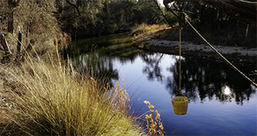
In Bandera County, a few hours west of Jacob’s Well, the developer of a Christian summer camp has applied for a permit to build a plant to treat 49,000 gallons of wastewater daily, and discharge it into Commissioners Creek. Photo © Keith Schneider / Circleofblue.org
HILL COUNTRY CONFLICTS
Upstream in the Hill Country, that same central idea of the sanctity of economic expansion is also paramount, and produces all manner of conflict and turmoil about water. For instance, the Texas Commission on Environmental Quality is considering permit applications from two Hill Country cities and six developers to build treatment plants for discharging 1.6 million gallons of wastewater every day into surface streams. Such discharges contain nitrogen, phosphorous, and other chemicals that encourage algae blooms, which have become much more common in Hill Country rivers famous for crystal-clear waters and clean limestone bottoms. The confrontations between wastewater plant developers and downstream residents are typically fierce. In Bandera County, a few hours west of Jacob’s Well, the developer of a Christian summer camp has applied to the TCEQ for a permit to build a plant to treat 49,000 gallons of wastewater daily, and discharge it into Commissioners Creek. The creek is the headwaters of Hondo Creek, a tributary of the Nueces River which feeds into Corpus Christi. The developer, Sam Torn, told reporters two years ago, “We’re very conscious of the land, of the surrounding land, of the need for clean water, for recreational water. Our kids will use that water for recreation, so we have to figure out the most ecologically sound and economically feasible way to dispose of our wastewater.” Dr. Denke, the activist with Friends of Hondo Canyon, opposes the permit. “Our little community funded an independent analysis of creek water,” she said. “There was undetectable phosphorus, and very low or absent nitrogen levels in this pristine creek. So the problem with wastewater discharge into the creek is that, in no uncertain terms, it will degrade the quality of water in the creek. Wastewater cannot be treated to the purity and clarity of the spring-fed water it will be replacing. It will produce green slimy polluted rivers that no one will want to swim in or drink.” The Texas Parks and Wildlife Department has fought its own battles with developers in a neighboring river basin. The agency owns and manages the 2,294-acre Honey Creek State Natural Area. A subdivision developer proposed three years ago to pour 500,000 gallons of treated wastewater daily into the creek, and was seeking a permit from the TCEQ. Carter Smith, the Wildlife Department director objected. In a letter in September 2018 he told the environment department the discharge could change the “nature of the creek, which in turn could affect aquatic life and the broader ecosystem of the watershed,” and could “adversely affect” endangered species like the golden-cheeked warbler. The state environment agency thumbed its nose at Carter and approved a draft permit. But that was before Texas citizens registered their displeasure with discharges to the Honey Creek State Natural Area and the TCEQ changed regulations for land application of wastewater. The developer withdrew its permit application in December and sought state approval for a different strategy – applying the treated wastewater to irrigate public spaces in the development. The agency is reviewing the application. Another active center of opposition over water quality concerns a $2 billion natural gas pipeline that its developer, Kinder Morgan, wants to build across the Hill Country from the Permian Basin to a terminal near Houston. Pipeline construction in Texas is essentially unregulated. The route of the 430-mile Permian Highway Pipeline is directly over the Hill Country’s sensitive limestone aquifers. David Baker’s Wimberley Valley Watershed Association joined Austin, several more cities, and a group of nonprofits in filing court motions that asserted two primary points. First, they argued, if the pipeline leaks, it will pollute drinking water. Second, its route violates the federal Endangered Species Act because construction and operation will damage habitat for the golden-cheeked warbler, an endangered songbird. In February, a federal district judge slapped that argument aside and ruled Kinder Morgan could proceed. But the water pollution case is active and expanding. On March 28, Kinder Morgan spilled 36,000 gallons of drilling fluid that drained into drinking water in Blanco County. The company did not notify county authorities or nearby homeowners, who found out when water that poured from faucets was brown, cloudy and unusable for any purpose. Residents turned bottled water and tanks to store trucked water. The Texas Railroad Commission issued a notice of violation and commissioners in neighboring Hays County revoked Kinder Morgan’s permits to cut through and bore under three county roads to build the project. “Groundwater is what western Hays County lives off of, and many of our residents out there rely on their groundwater for their daily lives,” said Hays County Commissioner Lon Shell. “We don’t want to do anything or allow anyone to do anything to jeopardize that.” Kinder Morgan announced it would reroute the pipeline to avoid the Blanco River, and executives insisted the project, which crosses 16 counties, would be finished. At the start of July, the pipeline was 65 percent complete, according to the company. The path to opening the pipeline, though, is strewn with more impediments. In May, the Railroad Commission began investigating complaints of significant soil erosion along the pipeline right of way. In June the Wimberley Valley Watershed Association and the Trinity Edwards Springs Protection Association filed suit in federal court asserting the spill was a violation of the Safe Drinking Water Act. New gas and oil pipelines are under pressure across the United States. Two gas pipelines were cancelled in Kentucky at the end of the last decade. In July, owners of a major gas pipeline under construction in the East cancelled the project because of public resistance, rising costs, and diminishing demand. The apparent end of the Atlantic Coast Pipeline after $3.6 billion had already been spent, was a seminal illustration of the profound disruption in the natural gas market from surplus supply and changing demand for liquid natural gas exports, domestic electrical generation, and plastics manufacturing. Concerned for the quality of the Hill Country’s water, Baker is actively working to make the Permian Highway Pipeline the next major gas transmission project to be cancelled. “When Kinder Morgan announced the Permian Highway back in 2018, I said it was the worst thing to ever happen to the Texas Hill Country and that even the construction would cause harm to our fragile karst aquifers,” he said. “The March 28th event and the threat to sole-source drinking water is beyond what I feared most. The residents and landowners in the path of this pipeline are not going to stand down.” 
Lady Bird Lake, a 416-acre reservoir in Austin, Texas, was built 60 years ago as a cooling pond for a power plant. It’s now a primary locus for recreation and flood control. Photo © Brian Lehmann/CircleofBlue.org
TEXAS WATER SUPPLY CHALLENGE IS NOT UNIQUE
Uncertainty and activism are two measures of the challenge that fast-growing communities face when they weigh new development against environmental constraints. Struggles over water occurring across the Hill Country and much of the rest of Texas are essentially the same as those unfolding in places in America where growth is highest and water resources are under the most stress — California, the Southwest, the Rocky Mountain West. For that matter, pursuit of economic growth and the reality of diminishing freshwater reserves are two trends rapidly moving in opposing directions almost everywhere on the planet, most notably China and India. The significant question Texas hasn’t answered is where it will find enough water by 2070. Responses are as varied as the regions. It took a four-year drought that ended in 2017 for California to decide to regulate groundwater, a primary source for agriculture and cities. In 2011, China discovered that its program of energy development, grain production, and construction of new cities was using so much water that by 2020 it would be 16 to 20 million acre-feet in deficit, a shortage so dire it could wreck China’s booming economy. A command-and-control society, China aggressively set out to shrink the deficit by quickly acting on three big initiatives. It moved much of its grain production from the dry Yellow River Basin to the wet northeast provinces. It closed water-thirsty coal mines, coal-washing stations, and water-cooled coal-fired power stations. And it built the largest water-conserving solar and wind electrical generating industry on Earth. In India, groundwater levels are steadily declining in the northwest states that produce much of country’s rice, wheat, and sugarcane. But the state and national governments encourage the trend. In a nation that has known pervasive hunger, food production is a paramount cultural objective. Keeping the 700 million Indians who are involved in agriculture happy is another prime objective. That’s why farmers pay nothing for water. They can use what they like. And they pay nothing for electricity to run ever-more powerful pumps needed to pull water to the surface that lies ever-deeper below ground. Texas is Texas. Texas is Big. Rich. Growing. Impulsive. Impressive. The significant question Texas hasn’t answered is where it will find enough water by 2070 — 8.5 million acre-feet, according to the Texas Water Development Board, or about half the Chinese water deficit — to keep over 50 million people safe, satisfied and thriving during deepening droughts. There are two ways to look at the challenge. The most optimistic view is so Texas. The Water Board, with its process of reviewing and revising the State Water Plan every five years lays out steps that are meant to give Texas guidance and time to figure it out. The more realistic and accurate assessment is that as Texas pursues its steep growth vector the hardships of serious droughts, like the one that unfolded in 2011, will grow worse. |


